Exploratory data analysis to support the second SNAI programming cycle
1 Interuniversity Department of Regional and Urban Studies and Planning, Politecnico di Torino and Università di Torino, Italy
2 Department of Architecture and Design, Politecnico di Torino, Italy
E-mail: cecilia.torriani@polito.it; alice.barreca@polito.it; manuela.rebaudengo@polito.it; diana.rolando@polito.it
*Corresponding author
Abstract. In 2012, the Italian “National Strategy for Inner Areas” (SNAI) was approved to enhance essential services (transport, education, healthcare) and boost economic growth in underdeveloped areas. After more than ten years since the first SNAI programming cycle (2014-2020) and at the beginning of the second one (2021-2027), this research analyses the thematic scopes and funding of projects implemented during the first SNAI cycle to support local authorities in the second cycle. The analysis focuses on the four Inner Areas of Piedmont to support the SNAI strategy development process in Valsesia, which was designated as one of the new Piedmont Inner Areas in 2022. The study, part of the B4R - Branding4Resilience project, uses government open data and Exploratory Data Analysis to examine the geographic and thematic distribution of SNAI interventions. Results show the allocation of projects and public funds, identifying popular themes and gaps. Among the most significant findings, the thematic scopes of “Transport and Mobility” and “Social Inclusion and Health” emerged as the most funded, while scopes such as “Environment”, “Research and Innovation” and “Employment and work” were significantly underrepresented, especially in Piedmont. Understanding the strengths and weaknesses of the first cycle is crucial for refining future strategies, avoiding past inefficiencies, and maximising the impact of upcoming interventions. Insights drawn from the analyses aim to support local authorities in addressing new interventions and actions, enhancing strategic planning for territorial projects.
Keywords: Inner Areas cohesion policy, SNAI strategies development, economic rural development.
JEL codes: R53, R58, R11, H5.
Index
2.1. The 2014-2020 SNAI programming cycle
2.2. The current debate around the SNAI implementation
4. Case study and data sampling
5.1. Projects’ thematic scopes and funds at the national and regional levels
5.2. Projects’ thematic scopes and funds in the 4 Piedmont Inner Areas
5.3. Lacks of thematic scopes in Piedmont SNAI strategies
6. Discussion and Recommendations
Italy (and, to some extent, Europe) is a polycentric territory, with a dense network of urban, rural and smaller centers, often characterized by the weakness of the services offered and the socio-economic conditions of the population. The study of this fragility, which began in the 1980s (Dematteis et al., 1983), focused on both the marginalization and isolation of territories and the degradation of the natural and cultural heritage, leading to the identification of inland areas as dependent on physical factors and/or political processes that did not take account of the potential of the territories to promote local development.
The marginalization and depopulation of these areas are the result of a complex, stratified process that has taken place over the last century. Socio-economic phenomena such as the progressive aging of the population, the decline of local economies and the reorganization of formal territorial aspects have increased these challenges since the end of the Second World War (Coordinamento rete nazionale giovani ricercatori per le aree interne, 2021).
In addition, these areas are characterized by limited accessibility, especially when compared to urban centers (Küpper et al., 2018; Moseley, 2023), and by disparities in terms of equity and social inclusion (Farrington and Farrington, 2005); despite their critical situation, inner cities have a lot of unexpressed potential (NUVV - Nucleo Valutazione e Verifica Investimenti Pubblici, 2020). These areas are characterized by the presence of environmental and cultural resources, with a strong commitment to product quality and environmentally sustainable production methods. Public administrations in these areas must also ensure active citizen participation, which fosters a strong sense of community (NUVV - Nucleo Valutazione e Verifica Investimenti Pubblici, 2020).
At present, the term ‘Inner Areas’ encompasses two key dimensions. Firstly, it refers to areas that are far from major urban centers, globalized networks, dynamic population trends and the widespread connectivity that characterizes the contemporary world - in other words, these areas exist outside the dominant development model (Pasqui, 2021). Secondly, it evokes a sense of ‘intimacy’ and ‘inwardness’, referring to places, landscapes and heritage that evoke a different time and space and offer alternative ways of living (Coordinamento rete nazionale giovani ricercatori per le aree interne, 2021). The stark contrast between urban centers and Inner Areas has led to disparities in terms of equity and social inclusion, affecting both the public and private economic sectors. For these reasons, Inner Areas have been supported by specific territorial policies (Caruso et al., 2021), which also serve as ideal laboratories for developing innovative territorial models and experimenting with interventions to address societal demands/needs that don’t find satisfaction in the traditional welfare system (NUVV - Nucleo Valutazione e Verifica Investimenti Pubblici, 2020). To address these issues, the European Spatial Development Perspective (ESDP) has ushered in a new era of policies, adopting a regional perspective and seeking to promote polycentrism (Barca et al., 2014a; Caruso et al., 2021; Farrington and Farrington, 2005; Moseley, 2023).
In the Italian context, an important milestone was reached in 2012 when the Minister for Economic Development approved the “National Strategy for Inner Areas” (SNAI), defined for the first time in the National Reform Programme (NRP) of the 2014-2020 Partnership Agreement (Lucatelli et al., 2014). The main objective of this strategic territorial initiative was to redress the imbalance in essential local services in 72 selected Inner Areas (Lucatelli, 2015) by improving public transport, education, social welfare and health care. At the same time, it aimed to stimulate economic growth and enrich the natural and cultural heritage of these regions. The overall long-term goal of SNAI was to reverse the trend of depopulation and ensure the vitality of these areas. A second important milestone was then reached in 2022, when 56 new Inner Areas were selected and admitted to the SNAI co-founding 2021-2027, including 43 areas and 13 coalitions - qualified as Inner Areas - supported by non-national funding (Servizio studi Camera dei deputati XIX Legislatura, 2023).
After more than ten years since the first SNAI programming cycle (2014-2020) and at the beginning of the second one (2021-2027), some Exploratory Data Analyses (EDA) on specific aspects of the first cycle implementation could support local authorities in addressing new strategies and actions to be proposed for the second cycle.
Therefore, the aim of this research is to analyze the thematic scope and the amount of public funding of the projects implemented during the first SNAI programming cycle and to highlight the main results at the national and regional levels. In addition, a more in-depth analysis is carried out at the regional level, focusing the attention on Piedmont Region, where the Valsesia territory was recently designated as new Inner Area and the SNAI strategy definition process is currently ongoing. This paper explores the hypothesis that the Valsesia new Inner Area could exploit the lessons learned from the four previous Piedmont Inner Areas to improve its strategic planning in the SNAI framework. This study was developed in the context of a collaboration between the Politecnico di Torino and the Valsesia Mountain Union, activated since 2020, in the context of the B4R - Branding4Resilience research project of national interest (PRIN 2017) (Ferretti et al., 2022; Malavasi et al., 2023; Rolando et al., 2024; Torriani et al., 2023). The following research questions guided the data analyses carried out in this paper: i) How should the new Inner Areas address their strategies in relation to the project thematic areas to be considered? ii) How much funding was allocated to each project? Two additional questions helped shape the direction of future research: iii) Which uncovered sectors should be prioritized for the fund allocation? iv) What design strategies could be selected (or excluded) in the upcoming cycle?
The results provided an in-depth analysis of the projects implemented in each of Italy’s Inner Areas during the first SNAI programming cycle (2014-2020), exploring how each area has managed and implemented its unique strategy. Specifically, in the context of the Piedmont Inner Areas, the research outlined both the strengths and the strategic shortcomings of the areas, providing valuable insights into the diversification and innovation of strategic planning that can support the Valsesia local authorities in their future programming.
The paper is structured as follows: Section 2 presents the literature background, with a bibliographic review and research on the implementation of SNAI in Italy. Section 3 presents the methodological approach adopted, while section 4 explains the data collection and sampling process. Section 5 discusses the results at both national and regional level, and section 6 provides concluding remarks.
2.1. The 2014-2020 SNAI programming cycle
Based on the principles of the European Cohesion Policy, SNAI has created its own geography of Italy’s internal areas, drawing up a new map of the territories and classifying them according to rules never before considered (Barca et al., 2014b). In addition to the main objectives of redressing the imbalance in essential local services, SNAI also defines some “minor” objectives: i) increasing the well-being of the local population and the local demand for labour and employment; ii) making better use of territorial capital; iii) reducing the costs of hydrogeological instability, the degradation of historical and architectural capital and the destruction of nature; iv) strengthening development and quality of life factors (NUVV - Nucleo Valutazione e Verifica Investimenti Pubblici, 2020).
The first selection process (started in 2012) was based on the proximity to the main service centers: the prevailing criteria were based on the distance of each municipality from essential services and the difficulty of reaching the so-called “poles”, where the following essential services are guaranteed: a secondary school, a hospital with a first level of Department of Emergency Urgency and Acceptance (DEA); a railway station of at least silver type (stations with medium/small systems, equipped only with regional/metropolitan services). The distance was calculated using an accessibility indicator, which measures the travel time to the nearest Pole.
These poles are generally urban centers with a full range of services such as schools, hospitals and railway stations (Barca et al., 2014b). Based on their distance from these poles, areas were categorized into four different types: Belt Areas (within 20 minutes), Intermediate Areas (up to 40 minutes away), Peripheral Areas (up to 75 minutes away) and Ultra Peripheral Areas (more than 75 minutes away from a pole).
The 2014-2020 SNAI programming cycle identified 72 internal areas, which are fairly homogeneous throughout Italy, covering a large part of the Italian territory, slightly less than 60% of the national territory, involving almost 52% of Italian municipalities (4181) and inhabited by 22% of the Italian population. The orography of the territory and the demographic size of the municipalities are indicators of fragility, with a risk of depopulation, low presence of essential services and weak territorial management (Strategia Nazionale delle Aree Interne, 2020). This ubiquitous presence of these Inner Areas underlines their importance as key elements of the Italian territory, which must be fully included in all public policy considerations, rather than being relegated to the status of ‘special cases’. It is unrealistic to assume that one-size-fits-all national policies can effectively address the diverse needs of the entire territory. Therefore, in formulating these policies, due consideration must be given to the unique characteristics and needs of all regions of the country. Furthermore, 59% of these agglomerations have fewer than 2,000 inhabitants and 25% have between 2,000 and 5,000 inhabitants (Strategia Nazionale delle Aree Interne, 2020). The total amount of funding was 1,167 million euros, co-financed by Laws n. 147/2013, n. 190/2014, n. 208/2015, n. 205/2017 and by EU funding programs such as the European Regional Development Fund (ERDF), the European Social Fund (ESF), the European Agricultural Fund for Rural Development (EAFRD) and the European Maritime and Fisheries Fund (EMFF).
In 2020, the SNAI programming cycle was strengthened and expanded with the identification of 43 new Inner Areas and new funds, which amounted to 172 million euros for the 2021-2027 years. The approval process of new Inner Areas was concluded with the CTAI (Inner Areas Technical Committee) of 29 September 2022; therefore, several local authorities are currently managing complex processes to identify their local strategies and the related activities to be funded, even if they cannot totally learn from the results of the first SNAI programming cycle (2014-2020), which outcomes are not fully known. This lack of knowledge can be overcome by critically analyzing the information at national scale, which describe the projects and the investments implemented in the past SNAI programming cycle that are still in the development phase.
Moreover, in 2020 the Marginal Municipalities Fund (Fondo Comuni Marginali) consolidates resources from two key provisions: the DPCM of September 24, 2020, which allocated funds to support economic, artisanal, and commercial activities in Inner Areas from 2020 to 2022, and the DPCM of September 30, 2021, which aimed to provide assistance to disadvantaged municipalities from 2021 to 2023. Following the dissolution of the Agency for Territorial Cohesion (DPCM 22 marzo 2024 - Soppressione dell’Agenzia per la coesione territoriale e trasferimento delle relative funzioni al Dipartimento per le politiche di coesione della Presidenza del Consiglio dei ministri), the responsibility for processing disbursement requests and transferring funds was assigned to the Department for Cohesion Policies and the South. According to Article 15 of Decree-Law No. 60 of May 7, 2024, these funds will not be revoked if utilized by December 31, 2025, where ‘utilization’ is defined as the formal identification of beneficiaries through a municipal resolution. Municipalities must follow specific procedures for requesting funds for the second and third annual installments, ensuring compliance with monitoring and reporting requirements.
2.2. The current debate around the SNAI implementation
Over the last 10 years, during the implementation of the first programming cycle, the national debate on SNAI and the international one on similar programs has been very active (Barca and Carrosio, 2020; Carrosio, 2019; Cotella et al., 2021; Cotella and Vitale Brovarone, 2020; Fenu and Giaccaria, 2023; Rolando et al., 2022; Scrofani and Accordino, 2023; Torriani et al., 2023), also highlighting positions of partial distance from the SNAI policy (Moscarelli, 2021; Rossitti et al., 2021; Sargolini M., 2016; Vendemmia, 2021; Vendemmia et al., 2022) and some interesting case studies (Andreoli and Silvestri, 2017; Carrosio, 2016; Pappalardo and Saija, 2020; Urso, 2016).
While Rossitti et al. (Rossitti et al., 2021) raised questions about the grid of indicators for the evaluation and selection of Inner Areas, Moscarelli (Moscarelli, 2021) proposed a thought-provoking analysis that offers insights into the critical assessment of this policy. First, it questions the methodology used to categorize municipalities as ‘poles’ or ‘centers’, with the provision of essential services determining their classification. The use of spatial and geographical distance alone, with a cut-off point of 20 minutes, to classify areas as ‘inner’ raises questions about the validity and inclusiveness of this approach. Secondly, the author analyzes territorial marginality: he observes that while the SNAI map only identifies degrees of peripherality based on the proximity of services, it overlooks a comprehensive understanding of marginality. Therefore, the direct link between inner space and true marginality is not entirely correct. The binary classification system proposed by SNAI divides Italy into two clear categories: municipalities that have services and are attractive, and municipalities that lack both. Finally, Moscarelli questions the political relationship between SNAI and the number of other parallel policies and actions that operate in the same areas.
However, the creation of a specific policy for peripheral areas has brought these areas into the public, cultural and academic debate (Carrosio, 2018; Dezio, 2021; Rolando et al., 2023). Refining the categorisation of Inner Areas based only on geographical location and proximity to urban centers oversimplifies the complexity of the categorisation. These factors, although important, are only two of those that describe the complex of marginalization of a territory (such as inner cities or regions in economic decline). Recent studies have offered an interpretation of marginality that goes beyond the structure based on geography and center-periphery dynamics (Vendemmia, 2021), defining it as a lack of socio-economic and political relations (Bock, 2016; Leimgruber, 2018; Pelc, 2006; Pessina, 2021).
In this new perspective, it is essential to also analyze the (social) services of citizenship in order to understand the reasons for the marginality of these territories and what are the useful tools for developing place-sensitive strategies for their redevelopment (Vendemmia et al., 2021). Given that the objective of the strategy is to guarantee the level of essential services throughout the territory, it is not specified why the three main criteria used to define the internal areas (accessibility, health and education) are identified as essential (Vendemmia et al., 2021). In 2018, the Foundational Economy Collective gave a definition of “goods and services [...] essential for the well-being of users”, which are those goods and services whose “limited access hinders life and limits its possibilities” (Vendemmia, 2021). These goods and services fall into three categories: i) the basic material economy (transport of goods and people, but also electricity, water and gas, internet access, accessibility, banking and postal services and, finally, the sale of cars); ii) the basic providential economy (universal services such as health, education, public order and public administration); iii) the neglected economy: activities that provide goods and services that are “perceived as essential” (Vendemmia, 2021). This category includes “ordinary and culturally embedded needs” that evolve according to socio-cultural parameters (Moretto, 2021).
Despite these findings, the SNAI is widely credited with focusing on territorial governance processes on disadvantaged areas and proposing a structural approach. The three primary services mentioned above are not sufficient to provide a comprehensive picture of the characteristics of the territories or to highlight their problems.
Thus, with the aim of studying methodologies to define appropriate solutions for marginal areas, some research has been carried out to propose the most appropriate solutions, experimenting analytical methods based on clustering algorithms to identify the prevailing problems, as in the case of the Inner Areas of Puglia (Marucci et al., 2020), others have taken into account the socio-economic characteristics of the inhabitants (Vendemmia, 2021), or others have analyzed criteria related to the presence of hydrogeological fragility or, more generally, environmental risks (Pessina, 2021).
Other researchers have focused on local behaviours, making the inhabitants the subjects who define their essential needs and the time thresholds for achieving them. In this case, the tools used are: focus groups, parallel tables, interviews, participatory surveys with the aim of creating “cognitive supply chains” (Golino and Marchetti, 2017) otherwise actions that combine local development with services based on experience and know-how rooted in the territory (Lucatelli, 2016).
The complexity of Inner Areas requires a dual approach: the use of analytical tools and the application of bottom-up methods involving active listening to the inhabitants. This combination of quantitative and qualitative research methods makes it possible to obtain a more complete analysis of this multifaceted phenomenon (Gaber and Gaber, 1997) and, at the same time, to identify the specific needs of the inhabitants of each area and the essential services they require (Vendemmia et al., 2021).
For these reasons, the quantitative exploratory analyses carried out in Section 5 can certainly provide useful indications on the implementation of the first SNAI programming cycle and thus support local authorities to address and strengthen the local strategy for the next programming cycle.
The research hypothesis underlying this study is that the adoption of a shared yet adaptable approach – avoiding rigid and pre-defined processes – is crucial to support Public Authorities in designing effective and context-sensitive territorial strategies for Inner Areas. Building on this assumption, a structured, multi-phase methodological approach was developed, encompassing clear goal definition, rigorous data preparation, and contextualised analysis. It was based on 4 subsequent phases, which used the output of the previous one as input for the following. Each phase includes different sub-phases, which are represented in Figure 1: Goal definition (1), Data collection and preparation (2), Data analysis (3) and Results interpretation (4).
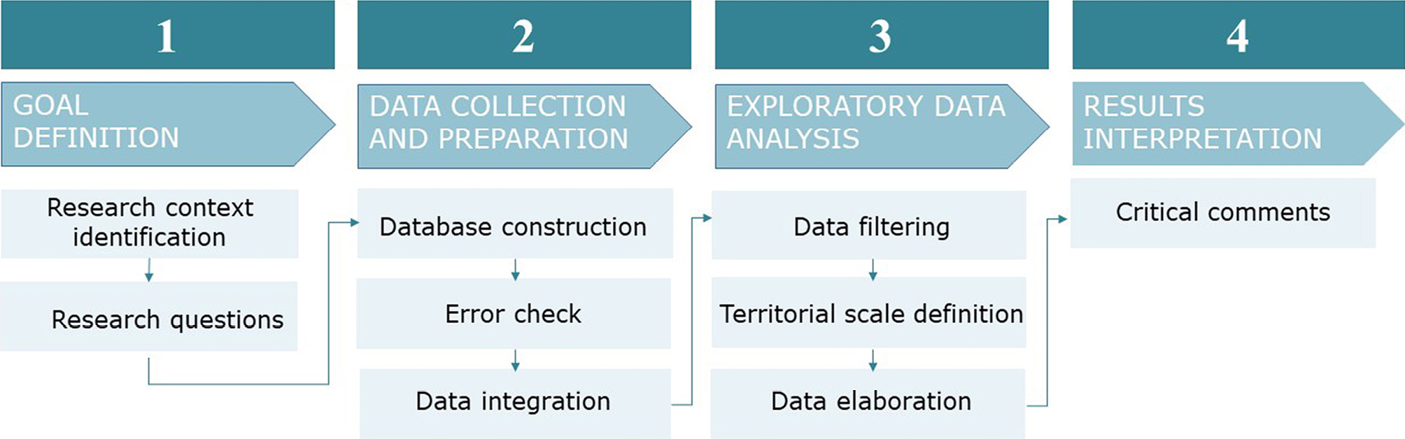
In the first phase (Goal definition) it is fundamental to address the context of the research and identify the research questions to outline the main objective of the study. In the second phase (Data collection and preparation), materials and data sources are identified, collected, harmonized, and managed in databases. In this phase, different steps of refinement allow to check data and correct errors, to build the final database used for the subsequent analyses. In the third phase (Data analysis), information and data are filtered and selected to build dedicated data samples to be analyzed. The data filtering sub-steps and selection process can be used at different territorial scales. The outputs and the results of this phase can be interpreted in the final step. During the fourth and final phase (Results interpretation) some critical comments and possible research developments are outlined. This phase can support Public Authorities to define efficient and effective territorial strategies or actions for inner territories.
4. Case study and data sampling
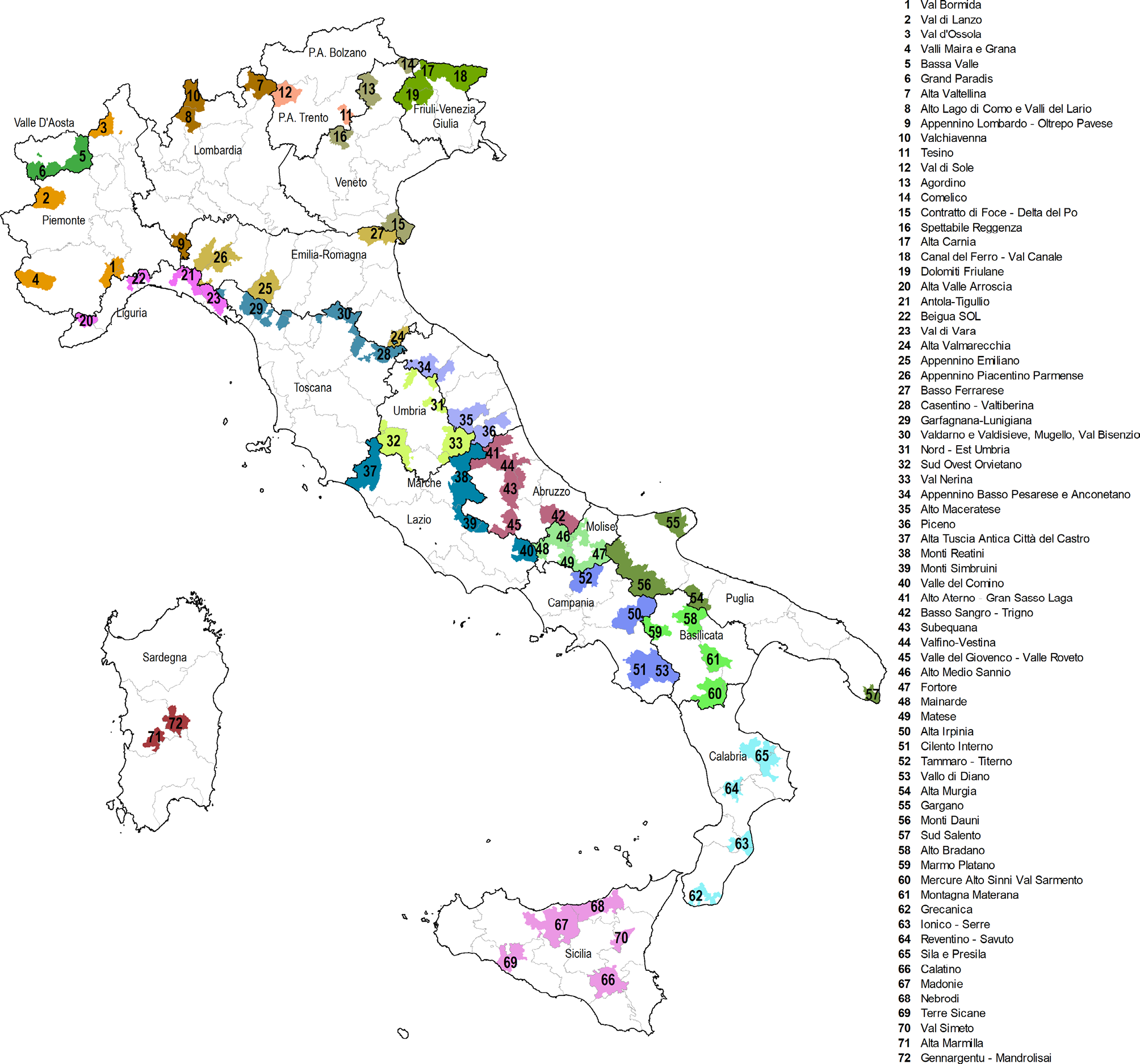
The first SNAI programming cycle (2014-2020) and its designated 72 Inner Areas represent the case study of this research. The 72 Inner Areas are located rather homogeneously through Italy: 21 areas are in South Italy, 28 in the Center and 23 in the North.
Figure 2 shows the nationwide selected 72 Inner Areas of the first SNAI programming cycle, classified into Belt areas, Intermediate Areas, Peripheral Areas and Ultra Peripheral (NUVV - Nucleo Valutazione e Verifica Investimenti Pubblici, 2020).
The 72 Inner Areas presented 2,258 projects, amounting to a total funding of 1,167 million euros, divided into:
– 266 million euros (from the resources allocated by Laws n. 147/2013, n. 190/2014, n. 208/2015 and n. 205/2017);
– 712 million euros (from the resources allocated by ERDF, ESF, EAFRD and EMFF EU funding programs);
– 132 million euros (from other public resources);
– 57 million euros (from private resources).
Therefore, to analyze the projects funded during the first SNAI programming cycle, a data sample was built by collecting data from three open data sources: the Department for Cohesion Policies and the South (formerly the Agency for Territorial Cohesion - SNAI section), OpenCoesione portal and the National Institute of Statistics (ISTAT).
From the website of the Department for Cohesion Policies and the South (formerly the Agency for Territorial Cohesion -SNAI section https://www.agenziacoesione.gov.it/strategia-nazionale-aree-interne/), it is possible to download data related to selection processes, planning strategies, and subsequent formalization of the SNAI strategy. Specifically, the available resources include: the annual report on Inner Areas (Strategia Nazionale delle Aree Interne, 2020), the official Map of Inner Areas, the List of Municipalities for each Inner Area, and the Guide to “Open Diagnosis”. These documents were used to analyze and compare the characteristics of different Inner Areas. When available, the following documents provided further detail: Approved Area Strategy Framework (summary), Framework Program Agreement, Approval documents, and Monitoring report. In particular, the “Open Kit” indicators served as the starting point to select the indicators identified in this research (Comitato Tecnico Aree Interne, 2020). These OpenKit indicators, published within the SISTAN network, are accompanied by essential metadata (including definition, calculation method, unit of measurement, reference period, and sources), and are periodically updated in line with each release of foundational data from official statistics (Nucleo di valutazione e analisi per la programmazione., 2023). The Open kit indicators can be organized into nine thematic categories:
1. Main characteristics: number of municipalities, population, surface area, ratio between the resident population and the territorial surface;
2. Demography: percentage of the resident population divided into age groups, population variation over the years;
3. Agriculture and sectoral specialization: utilized agricultural area and its variation over the years, ratio of people working in the sector, number of businesses active in the area;
4. Digital divide: population reached by ADSL and ultra-broadband;
5. Cultural heritage and tourism: number of state and non-state cultural places, number of visitors and accommodation rate;
6. Health: hospitalization rate, arrival time of first aid vehicles on site;
7. Accessibility: distance from the nearest pole, offer of the local public transport service, accessibility to the nearest railway station and intensity of railway and airport services;
8. School: number of schools, percentage of municipalities with primary schools and average number of pupils;
9. Associations between municipalities: number of municipalities in union and in agreement.
The second data source selected was the OpenCoesione portal (www.opencoesione.gov.it), which is an open government initiative on cohesion policies in Italy and promotes a widespread civic participation monitoring the effectiveness of interventions with the publication of data on funded projects. The open dataset contains all the information related to each reference project. The dataset (updated date: 30 June 2022) contains around 1700 projects described by 203 variables; among the most important are: conformation of each Inner Area (region, province, municipalities belonging to the areas); the eleven synthetic sectors used to catalogue the projects; a brief description of each project; funds divided by type (private, public, regional, province, municipality, European Union, etc.); composition of public funds (ERDF, ESF, EAFRD and EMFF); the progress of each project and the amount of its funds. Subsequent analyses do not incorporate the latest graphs and data, last updated on October 31, 2022, and subsequently uploaded to the website in February 2023. These recent updates were omitted, potentially impacting the comprehensiveness and accuracy of the subsequent analyses conducted.
Lastly, the National Institute of Statistics (ISTAT - https://www.istat.it/) provides data at the national, regional, provincial, and municipal levels and performs official statistics to support citizens and decision-makers. For this research, the portal was used to integrate the missing data (at the municipal scale) in the previous mentioned portals. In detail, the consistent joined data are the building density, the number of inhabitants, the altitude and the per capita income (updated date: 1 January 2022).
The final database developed for this research analysis comprises 2258 projects detailed by 203 variables (Table 1). As all data were sourced from official channels, potential compilation errors have not been considered in this initial phase of analysis. Nevertheless, some inconsistencies within the open data datasets were identified and the data structure was improved. Specifically, the database was checked and structured in 3 Geographic areas joining all Italian Regions: North Italy (Valle d’Aosta, Piedmont, Liguria, Lombardy, Trentino-Alto Adige, Veneto and Friuli-Venezia Giulia); Centre Italy (Emilia-Romagna, Tuscany, Marche, Lazio, Umbria, Molise, Abruzzo and Sardinia) and South Italy (Basilicata, Calabria, Campania, Puglia and Sicily). In each Italian Region there is a different number of Inner Areas: 2 in Trentino-Alto Adige, Valle d’Aosta and Sardinia; 3 in Friuli-Venezia Giulia, Marche, Tuscany and Umbria; 4 in Basilicata, Calabria, Campania, Emilia-Romagna, Lazio, Liguria, Lombardia, Molise, Piemonte, Puglia and Veneto); 5 in Abruzzo and Sicily.
| Data structure | Data content | Data value | Data source | |
|---|---|---|---|---|
| Field name | Vocabulary | Field type | ||
| Inner Areas variables | ||||
| Inner Area name | Name of the Inner Area | open | Text | OpenCoesione data |
| Number of Municipalities | number of municipalities forming part of the Inner Area | open | Number | OpenCoesione data |
| Inner Area size | It is the total area of a portion of territory | open | Number in km² | OpenCoesione data |
| Number of inhabitants of the entire Inner Area | Number of inhabitants of each Inner Area (sum of inhabitants of all the municipalities) | open | Number | OpenCoesione data |
| Density per inhabitant | number of people living in a specific area | open | Number in inhab./km² | OpenCoesione data |
| Italian Geographical Areas | Geographic location of each Inner Area | closed | Text: North, Centre, South | Authors’ elaboration on OpenCoesione data |
| Total funds in the Inner Area | Public (FESR, FSE, FEASR e FEAMP) and private funds | open | Number in Euros | Authors’ elaboration on OpenCoesione data |
| Average altitude | Average altitude of all municipalities of each Inner Area | open | Number in Meters (above sea level) | Authors’ elaboration on ISTAT data |
| Building density | Relationship between density and built morphology | open | Number in Building / m2 | ISTAT data |
| Number of Inhabitants in the Inner Area | Total number of inhabitants (sum of inhabitants in each municipality) | open | Number | ISTAT data |
| Per capita ratio | Amount of gross national product per capita in a certain period of time | open | Number in €/ inhabitants | ISTAT data |
| Projects variables | ||||
| Project title/name | project title reported in the SNAI local strategy report | open | Text | Department for Cohesion Policies and the South (SNAI section) |
| Project description | concise description of the project, where the purposes, the objective, and the location are explained | open | Text | Department for Cohesion Policies and the South (SNAI section) |
| Projects’ thematic scope | Project classification (and research) themes: aggregation of sectors and fields of intervention | closed | Text: Environment, Administrative capacity, Competitiveness of companies, Culture and tourism, Energy, Social inclusion and health, Education and training, Employment and work, Digital networks and services, Research and innovation, Transport and mobility. | OpenCoesione data |
| Project status | Work progress of the project | closed | Text: Completed, in progress, Settled, Not started | OpenCoesione data |
| Percentage of funds | Percentage of funds for the project’s sector out of the total | open | Number | Authors’ elaboration on OpenCoesione data |
| Percentage of number of projects | Percentage of number of projects for the project’s sector out of the total | open | Number | Authors’ elaboration on OpenCoesione data |
Furthermore, some data implementations were necessary and through the Department for Cohesion Policies and the South (former Agency for Territorial Cohesion -SNAI section) some missing projects were collected on the basis of the comparison of the “Framework Program Agreement” of each Inner Area. Table 1 shows the metadata of the main variables of the dataset.
The entire data sample was analyzed by using Exploratory Data Analysis (EDA), an investigative process that employs summary statistics and graphical tools to examine and interpret various variables: total public funds, private funds, number of projects, prevalent sectors, project status, geographical area, and Inner Area average altitude. In the following subsections data analysis results highlight the projects’ thematic scopes and funds at the national and regional levels (section 5.1) and in the 4 Piedmont Inner Areas (section 5.2), outlining some possible scopes to be considered in the context of the current second SNAI programming cycle (section 5.3).
5.1. Projects’ thematic scopes and funds at the national and regional levels
The whole data sample consisting of the 2258 projects referred to the 72 Inner Areas was analyzed to study the first SNAI programming cycle (2014/2020), in terms of geographical and thematic distribution of the projects, allocation of funding and progress of implementation. The geographical division in the different Italian Regions was assumed to make some comparisons on the distribution and allocation of funds because Italy presents territories with quite different economies, urban and administrative development.
The projects were clustered according to the 11 thematic scopes, defined by OpenCoesione on the basis of: EU priority themes and EU fields of intervention associated with the individual projects co-financed respectively in the two programming cycles 2007-2013 and 2014-2020; sectoral classifications of the Project Unique Code (CUP). (https://opencoesione.gov.it/it/faq/#!come-vengono-classificati-i-progetti-nei-temi-sintetici-di-open cohesion). By considering its specific goals, each project was related to a specific thematic scope (Table 2).
| Thematic scope | Goal of the projects |
|---|---|
| Environment | – distribution, collection and treatment of wastewater – waste management – risk prevention (defense works of inhabited centers, production sites and infrastructures), – prevention of coastal erosion and hydrogeological instability – slope consolidation – hydraulic cleaning actions – adaptation to climate change – promotion of biodiversity and nature protection |
| Administrative capacity | – public infrastructure to ensure public safety – institutional capacity building at national, regional and local level – improve the design of good policies and programs as well as their implementation, monitoring and evaluation – support activities for statistical production and technical assistance to administrations regarding the phases of the policy cycle (programming and implementation) – evaluations, studies and information and communication activities |
| Competitiveness of companies | – guarantee funds, funds for loans and access to credit – granting of co-guarantees and counter-guarantees through the credit guarantee system and venture capital funds – tools to support the entrepreneurial fabric through the creation of a new business – construction of new production plants or the expansion and modernization of existing production plants – improvement of the functionality of the production areas – program contracts to support investments promoted by large companies and the Integrated Benefit Packages (PIA) |
| Culture and tourism | – infrastructures for the protection and conservation of cultural heritage – interventions aimed at improving tourist services and at promoting and enhancing natural resources |
| Energy | – construction of plants for the production of energy from renewable sources – promotion of energy saving in productive sectors – actions for the development of diffused cogeneration (of electricity and heat) and trigeneration (of electricity, heat and cold) – diffusion of district heating and district cooling |
| Social inclusion and health | – improve the social inclusion of disadvantaged groups – investments in social and socio-health infrastructures – infrastructure for housing policies – infrastructure and health services – interventions to promote active and healthy aging and to promote active inclusion |
| Education and training | – promotion of school success and social inclusion in the fight against early school leaving – actions aimed at improving students’ learning and enhancing excellence – interventions in favor of school staff (such as training) – adult education courses |
| Employment and work | – active and preventive measures on the labor market – development of lifelong learning systems and strategies in enterprises – design and disseminate more productive ways of organizing work and support for self-employment – improve access to employment – increase the sustainable participation and advancement of women – reconcile work and private life |
| Digital networks and services | – broadband and ultra-broadband infrastructure and connectivity, – services to citizens and businesses, and aid to businesses relating to new technologies – multimedia educational networks and laboratories in schools, e-government projects – e-health and e-inclusion services |
| Research and innovation | – business financing for industrial research and experimental development projects – research offer by universities and research centers – technology transfer to the business world and advanced business services for research and innovation |
| Transport and mobility | – strengthening of railway lines, of the road network, of port connections, of intermodality – sustainable mobility interventions and public transport in urban areas |
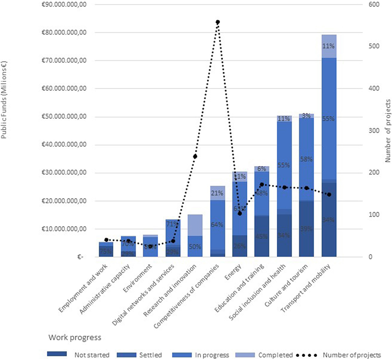
Firstly, the total number of projects was analyzed for each thematic scope and related to the projects’ status and to the received public funds (Figure 3). Results show that the amount of funds received is not directly proportional to the number of projects. For example, the funds related to “Transport and Mobility” were around 80 million euros but with a limited number of projects (149); on the contrary, there were many projects related to the thematic scope “Competitiveness of companies” (559), even if corresponding to less than 20 million euro of funds. Few funds (less than 10 million) were allocated to projects related to the thematic scopes “Environment”, “Employment and work” and “Administrative capacity”, while a great amount of funds (between 50 and 80 million euros) were allocated to projects related to “Transport and mobility”, “Culture and tourism” and “Social inclusion and health”.
After an overall analysis of projects and funds at the national level, the data analysis was focused on the number of projects for each thematic scope in each Italian Region. Hence, a comparative table (Table 3) was developed to outline all 72 Inner Areas selected by the first SNAI programming cycle (rows) and the related allocation of projects across the 11 thematic scopes (columns). Table 3 highlights the total number of projects funded in each Inner Area, the thematic scopes that many projects have focused on (green cells), those that have received less attention (yellow cells), and those for which no projects have been proposed (red cells).
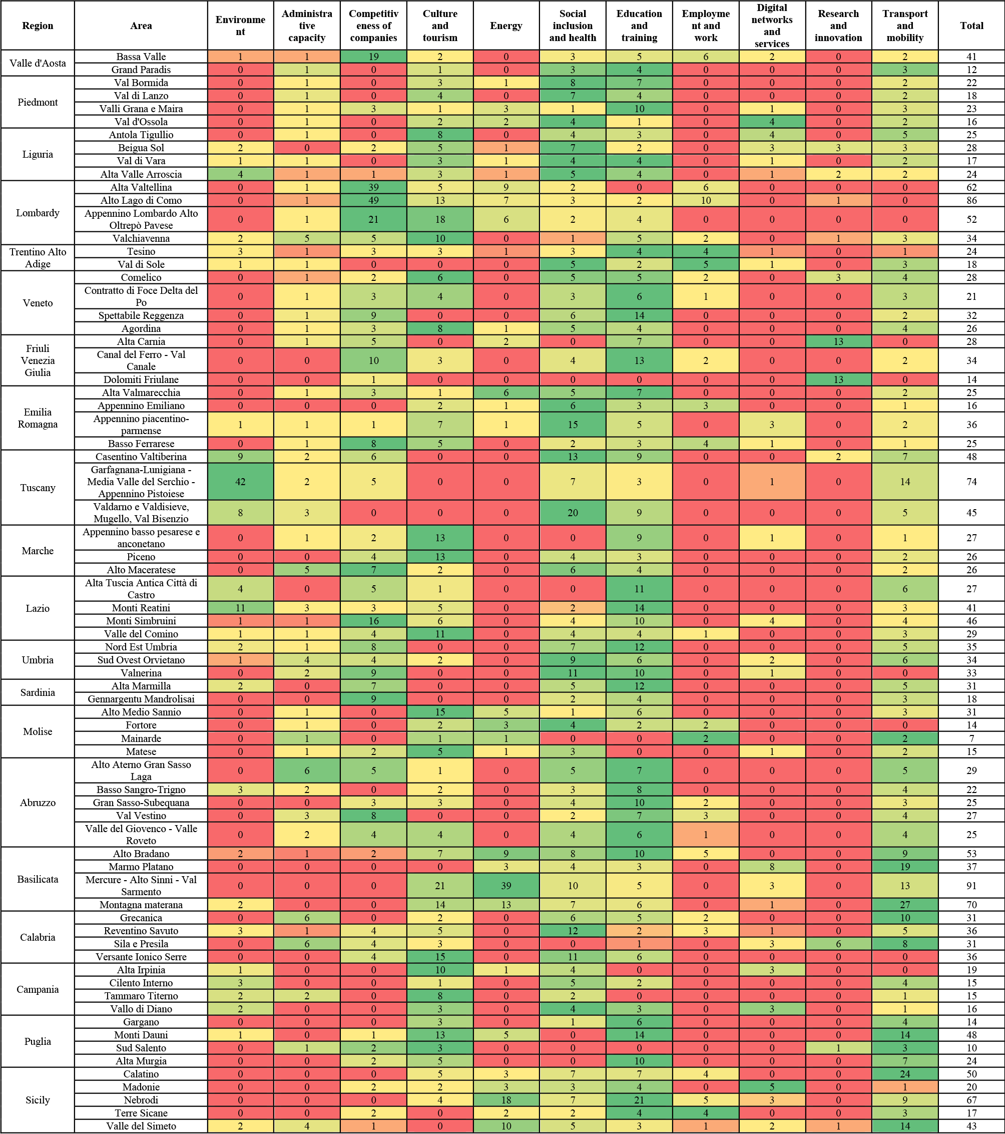
Firstly, the results show that at the national level, the thematic scopes with fewer focused projects were ‘Research and Innovation’, ‘Employment and Work’, ‘Digital Networks and Services’, and ‘Environment’, while those with a higher concentration of projects were ‘Transport and Mobility’, ‘Social Inclusion and Health’, and ‘Education and Training’.
Moreover, although each area presents specific characteristics closely tied to its territory, it emerges that certain thematic scopes still prevailed despite these local characteristics. From a geographical point of view, it emerges that in the Northern areas, the less common thematic scopes were “Environment”, “Research and innovation”, and “Employment and work”, while the most frequent ones were “Social inclusion and health”, “Education and training”, “Transport and mobility”. In the Central areas, the less common thematic scopes were “Research and innovation”, “Digital networks and services”, and “Employment and work”, while the most frequent ones were “Competitiveness of companies”, “Social inclusion and health”, “Education and training”. Lastly, in the Southern, the less common thematic scopes were “Research and innovation”, “Employment and work”, and “Administrative capacity”, while “Transport and mobility” emerged as the prevailing one.
5.2. Projects’ thematic scopes and funds in the 4 Piedmont Inner Areas
Considering the results outlined at the national level, this research focused on the Piedmont region, specifically delving into its four Inner Areas, founded by the first SNAI programming cycle: Val Bormida, Val di Lanzo, Valli Maira and Grana and Val d’Ossola.
Figure 4 shows that three of these areas (Valli Maira and Grana, Val di Lanzo and Val d’Ossola) are located at the national border and adjoin foreign territories (the first two border France while the third Switzerland); only Val Bormida faces the Liguria region.
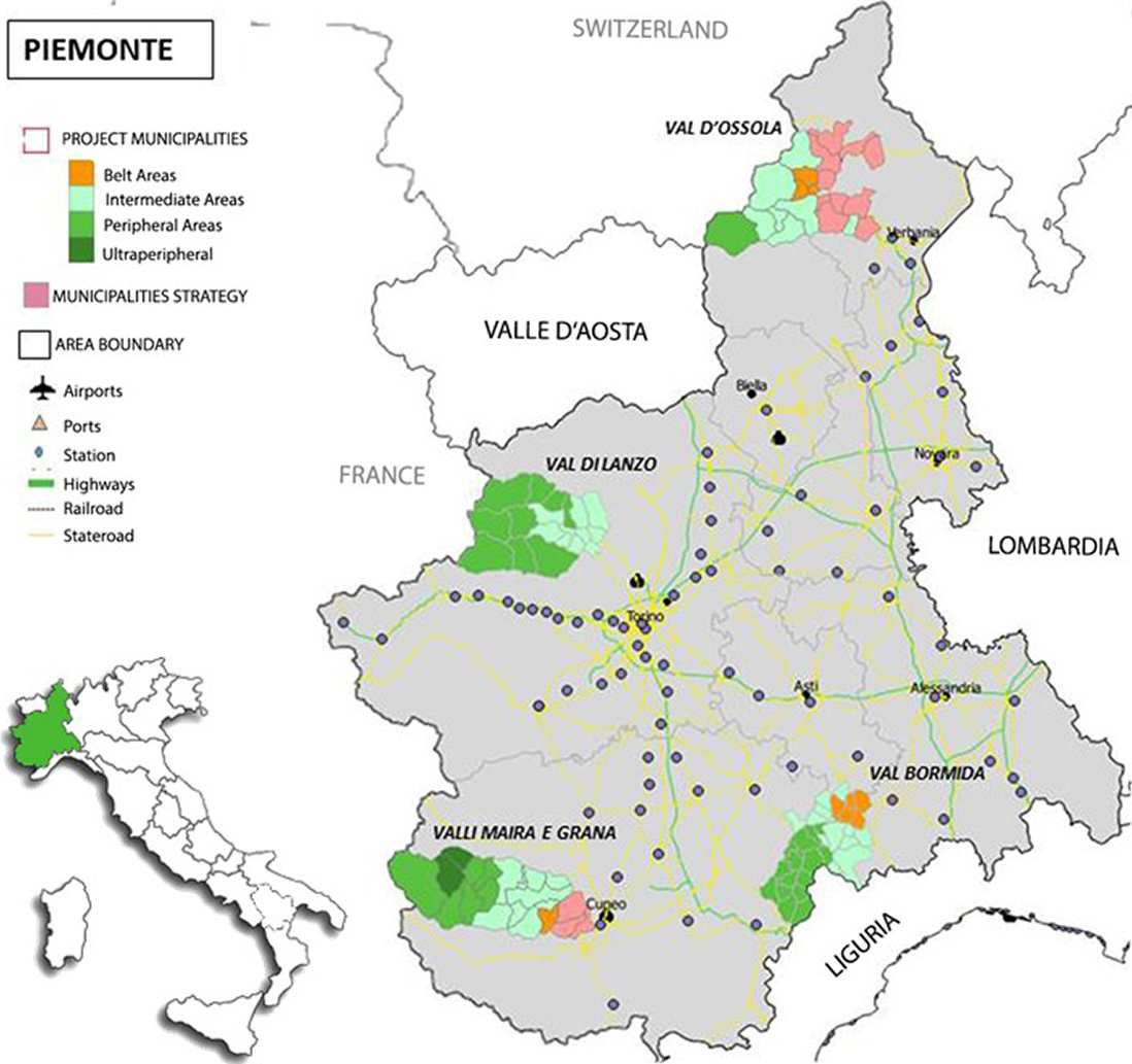
The four Piedmont Inner Areas are located in similar territorial contexts that determine common needs and strategies. Val Bormida is surrounded by the Bormida River, the Alta Langa and Monferrato hills, the Ligurian Apennines and the Alps: the territory is hilly with variable altitudes, with also some mountainous areas (Strategia d’Area, 2020). Val d’Ossola consists of three different valleys: Valli Anzasca, that is the most populous, and the smaller valleys Antrona and Bognanco, with a lower population density. This area is characterized by very small municipalities and villages mainly located at the bottom of the valley. The side valleys are characterized by inhabited centers positioned outside of the main routes (Bozza Strategia d’Area, n.d.). Val di Lanzo includes 3 valleys: Valle di Viù, characterized by the presence of lakes, Val d’Ala, which is the steepest, narrowest and wildest and preserves a great variety of alpine habitats, with woods, rocks and glaciers, and Val Grande, that is the northernmost of the three valleys, and has a wide valley floor (Accordo di programma quadro Regione Piemonte, 2020). Finally, Valli Maira and Grana can be divided into three areas based on their altitude: low, medium and high valleys. The municipalities in the lower valley possess features that make them well-suited for easy settlement development. The middle and upper valley sections have a very impervious territorial conformation characterized by the absence of road crossings (Strategia Nazionale Aree Interne, 2020). Table 4 shows the general geographical characteristics of these areas and their main SNAI strategy goals.
| Piedmont Inner Areas | Number of municipalities | Area size (km2) | Average altitude (masl) | Number of inhabitants 2011 | Density per inhabitant (inhab/km²) | SNAI strategy main goals |
|---|---|---|---|---|---|---|
| Val Bormida | 28 | 516 | 431 | 12,741 | 51.2 | · Recovery and Enhancement of the territory · Cohesion of a community |
| Val D’Ossola | 10 | 466 | 728 | 4,214 | 9 | · Saving of natural resources and energy · Enhancement of the creative and social function of work · Circular economy |
| Val Di Lanzo | 19 | 694 | 781 | 23,928 | 33.95 | · Initiatives related to the enhancement of health, education, and mobility issues |
| Valli Maira and Grana | 18 | 712 | 954 | 13,209 | 18.71 | · Strengthening and implementation of essential services (Education and training; Public transport; Social and health services) |
Table 4 shows that Val d’Ossola, Val di Lanzo and Valli Maira and Grana are located at a higher altitude than Val Bormida. The main SNAI strategy goals were different and demonstrated that the strategies were developed and personalized on each territory. Val di Lanzo and Valli Maira and Grana addressed similar strategies on education, mobility and health issues, while Val Bormida focused on social issues and Val d’Ossola on sustainable-energy challenges.
Table 5 presents the total number of projects and the funds allocated to the four Inner Areas of Piedmont. In terms of the total number of projects, the thematic scope on ‘Social Inclusion and Health’ predominated in three of the Inner Areas, although at the regional level, ‘Education and Training’ emerged as the most significant thematic scope. When considering the total amount of public funds, ‘Culture and Tourism’ was the primary focus in Val Bormida and Val di Lanzo, whereas in Val d’Ossola, ‘Energy’ took precedence. In Valli Maira and Grana, the largest share of funds was allocated to ‘Education and Training’.
| Val Bormida | Val D’Ossola | Val Di Lanzo | Valli Maira and Grana | Total (in Piedmont Region) | |
|---|---|---|---|---|---|
| Projects numbers and thematic scopes | |||||
| Total number of projects | 22 (28%) | 16 (20%) | 18 (23%) | 23 (29%) | 79 |
| Prevailing thematic scope based on the number of projects | Social inclusion and health | Social inclusion and health/ digital networks and services | Social inclusion and health | Education and training | Education and training |
| Number of projects of the prevailing thematic scope | 8 (10%) | 4 (5%) | 7 (8,8%) | 10 (12,6%) | 22 (27,8%) |
| Projects amount of public funds and thematic scopes | |||||
| Total amount of public funds | 6,889,330.00 € (20%) | 6,612,500.00 € (19%) | 9,077,500.00 € (27%) | 11,640,000.00 € (34%) | 34,219,330.00 € |
| Prevailing thematic scope based on funds | Culture and tourism | Energy | Culture and tourism | Education and training | Education and training |
| Public funds of the prevailing thematic scope | 1,413,428.00 € (4%) | 1,060,000.00 € (3%) / 2,527,500.00 € (7%) | 1,802,790.00 € (5%) | 4,714,000.00 € (14%) | 7,239,637.00 € (21%) |
| Number of projects of the prevailing funds | 3 (3.7%) | 2 (2.5%) | 4 (5.0%) | 10 (12.6%) | 22 (27.8%) |
| Public funds of the most funded projects | 1,950,000.00 € (6%) | 3,000,000.00 € (9%) | 2,852,500.00 € (8%) | 4,714,000.00 € (14%) | 7,239,637.00 € (21%) |
| Average project funding for the main thematic scope (Number of projects) | 176,678.50 € | 265,000.00 € / 631,875.00 € |
257,541.43 € | 471,400.00 € | 329,074.41 € |
| Average fund per project of the prevailing thematic scope (project funds) | 650,000.00 € | 1,500,000.00 € | 713,125.00 € | 471,400.00 € | 329,074.41 € |
An analysis of the number of projects by frequency for each Inner Area of Piedmont and thematic scope, as shown in Table 3, reveals that no projects in Piedmont were directed towards the thematic areas of ‘Environment’, ‘Employment and Work’, or ‘Research and Innovation’. The highest number of projects were addressed towards “Social inclusion and health”, “Education and training”, “Culture and tourism”, while just few projects towards “Competitiveness of companies” and “Digital networks and services”. Focusing the attention on the specific issues that characterized the SNAI strategy goals in Piedmont, Table 6 summarizes them by means of keywords for each Inner Area and thematic scope.
| Val Bormida | Val di Lanzo | Valli Maira and Grana | Val D’Ossola | |
|---|---|---|---|---|
| Administrative capacity | Technical assistance | Technical assistance | Economic and financial management of the programme, Communication and monitoring plan | Technical assistance |
| Competitiveness of companies | Development of non-agricultural enterprises | Enhancement of the agricultural, agri-food and forestry sectors, Development of digital services for tourism | Creation of a territorial brand, Development of entrepreneurial activities, Improvement and support of the socio-economic context | / |
| Culture and tourism | Digital platform for tourist services, Enhancement of local heritage | Creation of a widespread cultural network, Protection of areas of environmental value | Promotion and marketing of local products, Providing services useful for tourist use | Environmental enhancement of the thermal baths, design and construction for the development of the wood supply chain, digitization of the Ossola museum, recovery of nuts and bolts |
| Energy | Energy efficiency of public buildings | / | Energy saving and production of electricity from renewable sources | Construction of a hydroelectric plant for the production of self-consumption, Construction of wood chip cogeneration units |
| Social inclusion and health | Telemedicine, widespread medical centers | Telemedicine, widespread healthcare, Coordination of the activity of healthcare professionals Strengthening of pharmacies | Integrated family assistance services | Telemedicine, community nurses, RSA territorial service networks, development and training action for the Alpine mountains |
| Education and training | Educational workshops, opening of new nursery schools | Networking of local schools, activation of new study paths | Construction of a new school complex, making the school complex safe, expanding the school training offer | Extension of school openings |
| Digital networks and services | / | Reorganization and optimization of local public transport, Activation of flexible transport services | Broadband and ultra-broadband services | / |
| Transport and mobility | Mobility reorganization, Creation of collective transport services | New runways to land helicopter rescue | TPL efficiency Creation of supplementary services in the area and ride sharing |
Enhancement of local public transport, Preparation of a public transport on call for tourists |
Results highlight that projects “Social inclusion and health”, “Administrative capacity”, “Culture and tourism” were quite similar, while those related to “Education and training”, “Digital networks and services”, “Energy” reflected the specific needs of the territory. Moreover, the projects related to cultural issues and to the organization of transports were rather similar.
5.3. Lacks of thematic scopes in Piedmont SNAI strategies
As mentioned before, the 4 Piedmont Inner Areas decided not to address their strategies and investments towards the following thematic scopes: “Environment”, “Employment and Work” and “Research and Innovation”. Therefore, a deeper analysis of the projects related to these scopes developed at the national level could be useful to address new strategies in the context of the second SNAI programming cycle. By understanding the strategic approaches and related implementations adopted in other Inner Areas, some best practices can be identified and similar initiatives can be developed elsewhere. Table 7 compares, for each thematic scope, the number of projects at the national level and in the Piedmont region, highlighting the Italian Inner Area that developed the highest number of projects related to each scope.
| Number of projects at national level | Number of projects in Piedmont region | Inner Area with the highest number of projects | ||
|---|---|---|---|---|
| Environment | 117 | 0 | 42 | Garfagnana-Lunigiana - Media Valle del Serchio - Appennino Pistoiese |
| Administrative capacity | 90 | 4 | 6 | Alto Aterno Gran Sasso Laga / Grecanica |
| Competitiveness of companies | 318 | 3 | 49 | Alto Lago di Como and Valli del Lario |
| Culture and tourism | 327 | 10 | 21 | Mercure – Alto Sinni – Val Sarmeto |
| Energy | 155 | 6 | 35 | Mercure – Alto Sinni – Val Sarmeto |
| Social inclusion and health | 331 | 20 | 20 | Valdarno e Valdisieve, Mugello, Val Bisenzio |
| Education and training | 406 | 22 | 21 | Nebrodi |
| Employment and work | 80 | 0 | 10 | Alto Lago di Como and Valli del Lario |
| Digital networks and services | 64 | 5 | 8 | Marmo Platano |
| Research and innovation | 46 | 0 | 13 | Alta Carnia / Dolomini Friulane |
| Transport and mobility | 323 | 9 | 27 | Montagna materana |
Therefore, in order to focus on those thematic scopes that were not considered in Piedmont during the first SNAI programming cycle, the Italian Inner Areas to be analyzed are the following: Garfagnana-Lunigiana - Media Valle del Serchio - Appennino Pistoiese (for “Environment”), Alto Lago di Como and Valli del Lario (for “Employment and work”) and Alta Carnia (for “Research and innovation”).
The Garfagnana-Lunigiana - Media Valle del Serchio - Appennino Pistoiese Inner Area, located in Tuscany Region, directed a large number of projects towards environmental issues (57%), although it is notable that these projects accounted for only a small percentage of the total invested funds (10%). Table 8 shows a detailed breakdown of the number of projects and the total funds allocated both for the whole strategy and for the “Employment and work” projects.
| Garfagnana-lunigiana - Media Valle del Serchio - Pistoia Apennines | ||
|---|---|---|
| Whole strategy | “Environment” Projects | |
| Total number of projects | 74 | 42 (57%) |
| Total amount of public funds | 5,723,859.58 € | 594,092.73 € (10%) |
| Average fund per project | 77,349.45378 € | 14,145.065 € |
This Inner Area strategy was focused on the mountainous areas, where signs of structural weakness emerged, including the significant distance from essential services, which had led to depopulation, an ageing population, loss of functions, and inadequate soil protection (Accordo di programma quadro Regione Toscana, n.d.). The general goal was to counter these factors by leveraging the specific characteristics of the territory and its communities – territorial identity and sense of belonging – and the growing local development model, particularly the tourism-rural sector, enhancing local agricultural production, historical centers, and landscape and environmental assets.
According to the characteristics of its environment, this Inner Area sets the protection of the territory as a relevant scope through two lines of intervention: prevention against hydrogeological instability and seismic mapping of the building heritage of the entire area (Accordo di programma quadro Regione Toscana, n.d.). The high potential risk of landslides, floods, and seismic events represents a constant threat to the area. By considering the continuous and recent natural disasters, the maintenance and protection of the territory emerged as a priority to improve its safety, which is not sufficient and, above all, not focused on the actual needs of the inhabitants. The interventions were mostly reactive and focused on restoring structures and areas damaged by events after they had occurred, leaving little room for comprehensive prevention programs. The goal set by the Inner Area was to shift from a “damage repair” policy to a prevention policy through the maintenance of surface water networks, minor water bodies, vegetation clearing, and restoring full functionality of rainwater disposal systems. These actions aimed to make the area more attractive and livable for the population, who could, in turn, contribute to its better maintenance and the promotion of economic activities. The expected results included the implementation of a widespread maintenance plan with a preventive focus on mitigating hydrogeological instability, as well as the optimization of maintenance efforts for surface water drainage systems, reducing the need for costly restoration and recovery interventions. From a seismic risk point of view, the establishment of a database available for the classification of risk situations represented the indispensable step towards the precise seismic qualification document and the definition of precise preventive consolidation interventions (Accordo di programma quadro Regione Toscana, n.d.).
The Alto Lago di Como and Valli del Lario Inner Area, located in Lombardy Region, presented both the highest number of “Employment and work” (10 projects) and of “Competitiveness of companies” (49 projects); however the strategy is clearly aimed at improving the competitiveness of companies. Table 9 shows in detail that there is a proportional distribution between the number of projects and the amount of public funds.
| Alto Lago di Como And Valli del Lario | ||
|---|---|---|
| Whole strategy | “Competitivness of companies” projects | |
| Total number of projects | 86 | 49 (57%) |
| Total amount of public funds | 8,029,561 € | 1,961,250 € (10%) |
| Average fund per project | 93,367 € | 40,026 € |
This Inner Area strategy was oriented towards a strong territorial cohesion action aimed at recomposing the fragmentation, freeing up energy and supporting excellence (Accordo di programma quadro Regione Lombardia, n.d.). The identified priorities for strategic actions were two: i) strengthening territorial networks for a reorganization of functions and relationships that overcomes the conditions of fragmentation and lays the foundations for a systemic vision of the area; ii) working on and with young people, to strengthen their skills and abilities to move in the labour market, but also to increase their awareness and proactivity regarding the effective opportunities that this Inner Area can offer in terms of life and professional opportunities (Accordo di programma quadro Regione Lombardia, n.d.). In particular, a strategy goal was to strengthen industrial manufacturing excellence, which so much shaped the economy and the local labour market. Nevertheless, to be able to maintain its condition and position in the international markets on which it competes, it was considered important to strengthen both industrial research activities for the innovation of processes, products and organization and the training of workers to make them more capable of combining traditional knowledge with the opportunities provided by the research itself (Accordo di programma quadro Regione Lombardia, n.d.).
Lastly, the Alta Carnia Inner Area, located in Friuli Venezia Giulia Region, presented the highest number of “Research and innovation” projects. Table 10 shows that about half of the proposed projects are focused on research and innovation issues, which are related to more than 60% of public funds.
| Alta Carnia | ||
|---|---|---|
| Whole strategy | “Research and innovation” projects | |
| Total number of projects | 28 | 13 (46%) |
| Total amount of public funds | 1,994,680.11 € | 1,249,542.70 € (63%) |
| Average fund per project | 71,238.60 € | 96,118.70 € |
The strategy of this Inner Area was aimed not only to reverse the increase in the number of inhabitants (due to depopulation trend) that impacted also on productive activities and services, but also to enhance some strategic sectors, related to forest resources, tourism, as well as natural resources (Accordo di programma quadro Regione Friuli Venezia Giulia, n.d.).
Instead, the primary goal of the local SNAI strategy was twofold: i) to ensure the well-being of residents by strengthening essential services (education, health and mobility); ii) cultivating the area’s potential and appeal from a tourism perspective by supporting local economy chains.
This strategy was focused on the development of research innovation projects and was supported by local actors from the territory, such as Mountain community, Policy Coordination Service, Region, Regional Administration, as well as active workers of the area. The active involvement of local communities had a twofold objective: to inform the residents and to outline the SNAI strategy on the basis of data, experiences, and feedback. The constant dialogue between stakeholders along the whole strategy definition process enabled the selection of choices that are truly suitable for the area.
6. Discussion and Recommendations
The findings of this research highlight critical lessons for the second SNAI cycle (2021-2027), emphasising the importance of a more context-specific and flexible approach to improve effectiveness. This is particularly relevant in light of the most recent release (2023) of the OpenKit indicators (Nucleo di valutazione e analisi per la programmazione, 2023) which provides updated metrics and methodological guidance for monitoring and planning. One key insight is that Inner Areas should not be treated as homogeneous entities: while they share common challenges – physical and digital marginality, depopulation, and weak local economies – each area has unique socio-economic and environmental characteristics that require tailored solutions. The adoption of a shared but adaptable approach, avoiding rigid and pre-defined processes, is crucial for success.
Furthermore, the Covid-19 pandemic has introduced new dynamics that policymakers must consider. The increased preference for housing in rural areas and the expansion of remote work present opportunities for repopulation, but only if adequate digital infrastructure is in place. Addressing the digital divide is therefore a priority, as access to reliable internet is now an essential service, much like healthcare or transport. Marginal areas should offer not only essential services but also a high quality of life (Stankulova et al., 2023; 2024) to attract new residents.
Another key policy implication is the need for better coordination between national strategies and local governance. While top-down policies provide essential funding and a general framework, bottom-up engagement is crucial for ensuring that interventions reflect the specific needs of each territory. Strengthening the role of local authorities and community stakeholders in decision-making processes would enhance policy effectiveness and project sustainability.
Moving forward, the next step of this research will be to monitor the management and impact of the second SNAI cycle strategies. However, challenges remain in collecting updated and reliable data, as unclear responsibilities regarding data reporting and accessibility continue to hinder transparency. Additionally, future studies will investigate why some areas were not reconfirmed in the second SNAI cycle and whether the pandemic and economic crisis influenced the distribution of projects and funds. By learning from past shortcomings and refining strategic planning, Inner Areas can transition from marginality to vibrancy, becoming sustainable and thriving communities.
Inner Areas represent marginal and fragile territories, both environmentally and, more significantly, from social, economic, and institutional perspectives. The first cycle of the National Strategy for Inner Areas (SNAI) aimed to address long-standing and deeply rooted challenges in these regions. As Raffestin (Raffestin, 1989) emphasized, planning and investment in fragile areas, particularly in mountain regions, require a careful balance between environmental, social, and economic dimensions, as they continuously interact in a process of rebalancing. However, the findings of this study suggest that the first SNAI cycle did not always achieve this balance (Cinieri and Tognon, 2021).
The analysis of 2258 projects across the 72 Inner Areas funded by the first SNAI cycle revealed that the distribution of funds did not always correlate with the number of projects or local needs. For instance, ‘Transport and Mobility’ received 80 million euros with relatively few projects (149), while ‘Competitiveness of Companies’ had a much larger number of projects (559) but less than 20 million euros. One surprising finding was the lack of attention to environmental projects, despite the fact that addressing environmental risks was a key SNAI objective (2014-2020), especially given the known challenges of hydrogeological instability and inadequate territorial protection (Pessina, 2021). Similarly, ‘Competitiveness of Companies’ and ‘Digital Networks’ saw limited focus. Additionally, the lack of projects in the ‘Employment and Work’ scope contrasts sharply with the widespread issues of depopulation and youth migration from these areas, which hinder local business development.
To contextualize the analysis of the examined projects at the national level, it is important highlighting that official data from the Department for Cohesion Policies and the South were integrated with other data sources. For instance, according to the former Agency for Territorial Cohesion, regional fact sheets provided a synthetic overview of demographic, economic, and social indicators for regions and autonomous provinces, along with data on national and EU resources allocated to cohesion policies during the 2007-2013 and 2014-2020 programming cycles (https://politichecoesione.governo.it/it/).
Additionally, the analysis was based also on the Italian National Institute of Statistics (ISTAT) database, containing 366 indicators available at the regional level, by macro-area, and for the target areas of different development policy cycles. These sources provided official data for understanding the relevance of the examined projects in a regional context, enabling a more in-depth analysis that was directly correlated to the national dimension.
From a methodological standpoint, this study presents both strengths and weaknesses. The use of open government data allowed for a comprehensive, large-scale assessment of the first SNAI cycle, identifying patterns and discrepancies in funding allocation. The Exploratory Data Analysis (EDA) provided valuable insights into how different regions approached development challenges. However, limitations include incompleteness and inconsistencies in available data, which complicate efforts to track project outcomes. Moreover, this study primarily focused on funding allocation, while qualitative aspects – such as the effectiveness of interventions and local perceptions – require further investigation.
Regarding the initial research question – How were funds and projects distributed in the first SNAI cycle, and what lessons can be drawn for future planning? – the findings indicate that funding distribution was uneven across thematic areas and territories, often misaligned with local priorities. This suggests that a more tailored and participatory approach is needed to improve future interventions.
A more in-depth analysis was carried out at the regional level, focusing the attention on Piedmont Region, to explore how the Valsesia new Inner Area could exploit the lessons learned from the four previous Piedmont Inner Areas to improve its strategy definition process. During the first SNAI cycle, Piedmont’s Inner Areas displayed diverse strategies, tailoring interventions to local needs. While Val di Lanzo, Valli Maira, and Grana prioritized education, mobility, and healthcare, Val Bormida focused on social issues, and Val d’Ossola emphasized sustainable energy.
However, in Valsesia the SNAI strategy definition process was marked by significant uncertainties and critical issues, particularly in identifying local priorities and selecting the thematic scopes to address the overall strategy, specific actions and the related funding. The analysis of other Piedmont Inner Areas showed both best practices and pitfalls, which could guide Valsesia’s future strategy and foster a stronger stakeholder involvement, better alignment between funding and territorial needs, and a more integrated long-term vision for economic development.
“B4R Branding4Resilience. Tourism infrastructure as a tool for the enhancement of small villages through resilient communities and new open habitats” (Project number: 201735N7HP) is a research project of relevant national interest (PRIN 2017 – Youth Line) funded by the Ministry of University and Research (MUR) (Italy) for the four-year period 2020–2024.
Accordo di programma quadro Regione Friuli Venezia Giulia (n.d.). Area Interna Alta Carnia.
Accordo di programma quadro Regione Lombardia (n.d.). Area Interna Alto Lago di Como e Valli del Lario.
Accordo di programma quadro Regione Piemonte (2020). Area Interna Valli di Lanzo.
Accordo di programma quadro Regione Toscana (n.d.). Area Interna Garfagnana - Lunigiana - Mediavalle del Serchio - Appennino Pistoiese.
Andreoli, A., & Silvestri, F. (2017). Tourism as a driver of development in the Inner Areas. Italian Journal of Planning Practice, 7(1), 80–99.
Barca, F., & Carrosio, G. (2020). Un modello di policy place-based: la Strategia Nazionale per le Aree Interne. In Osti, G., & Jachia, E. (Eds.). Attivaree. Un disegno di rinascita delle aree interne. Bologna, Il Mulino.
Barca, F., Casavola, P., & Lucatelli, S. (2014a). A strategy for Inner Areas in Italy: definition, objectives, tools and governance. Materiali Uval Series, 31.
Barca, F., Casavola, P., & Lucatelli, S. (2014b). Strategia Nazionale Per le Aree Interne: Definizione, Obiettivi, Strumenti e Governance. Available at: https://www.agenziacoesione.gov.it/wp-content/uploads/2020/07/MUVAL_31_Aree_interne.pdf (Accessed 28 October 2024).
Bock, B. B. (2016). Rural marginalisation and the role of social innovation; a turn towards nexogenous development and rural reconnection. Sociologia Ruralis, 56(4), 552–573. https://doi.org/10.1111/soru.12119
Bozza Strategia d’Area (n.d.). Area Pilota delle Valli dell’Ossola.
Carrosio, G. (2016). A place-based perspective for welfare recalibration in the Italian inner peripheries: the case of the Italian strategy for inner areas. Sociologia E Politiche Sociali, 3, 2016, 50–64. https://doi.org/10.3280/sp2016-003004
Carrosio, G. (2018). Le aree interne da luogo di disuguaglianza a opportunità per il paese. In Paolazzi, L., Gargiulo, T., & Sylos Labini, M. (Eds.). Le sostenibili carte dell’Italia. pp. 167–186. Venezia, Marsilio.
Carrosio, G. (2019). I margini al centro: L’Italia delle aree interne tra fragilità e innovazione. Roma, Donzelli Editore.
Caruso, N., Pasqui, G., Tedesco, C., & Vassallo, I. (2021). Rigenerazione dello spazio urbano e trasformazione sociale. Introduzione. In Caruso N., Pasqui G., Tedesco C., & Vassallo I. (Eds.). Rigenerazione dello spazio urbano e trasformazione sociale. Atti della XXIII Conferenza Nazionale SIU. DOWNSCALING, RIGHTSIZING. Contrazione demografica e riorganizzazione spaziale, Torino, 17-18 giugno 2021, vol. 05. Planum Publisher e Società Italiana degli Urbanisti, Roma-Milano, 5–8.
Cinieri, V., & Tognon, A. (2021). Riflessioni sulla montagna italiana, tra fragilità e sviluppo sostenibile. Territorio, 97, 2, supplemento, 2021, 95–101. https://doi.org/10.3280/tr2021-097-Supplementooa12932
Comitato Tecnico Aree Interne (2020). Guida agli indicatori della «diagnosi aperta» della strategia per le aree interne. Available at: https://politichecoesione.governo.it/media/hfpbntyt/guida_interpretazione_degli_indicatori_per_la_diagnosi_aperta-e-avvertenze.pdf (Accessed 28 October 2024).
Coordinamento rete nazionale giovani ricercatori per le aree interne (2021). La genesi del volume, passione e curiosità . In Dezio, C., D’Armento, S., Kercuku, A., Moscarelli, R., Pessina, G., Silva, B., & Vendemmia, B. (Eds.). Le Aree Interne Italiane. Un banco di prova per interpretare e progettare i territori marginali. Trento, LIStLAB.
Cotella, G., & Vitale Brovarone, E. (2020). The Italian National Strategy for Inner Areas: A place-based approach to regional development. In Bański, J. (Ed.). Dilemmas of Regional and Local Development. London, Routledge. https://doi.org/10.4324/9780429433863-5
Cotella, G., Vitale Brovarone, E., & Voghera, A. (2021). Italy testing the place-based approach: River agreements and national strategy for inner areas. In Bevilacqua, C., Calabrò, F., & Della Spina, L. (Eds.). New Metropolitan Perspectives. NMP 2020. Smart Innovation, Systems and Technologies, vol 178. Cham, Springer. https://doi.org/10.1007/978-3-030-48279-4_11
Dematteis, G., Magnaghi, A., & Magnatti, P. (1983). L’Italia emergente. Indagine geo-demografica sullo sviluppo periferico. Milano, Franco Angeli.
Dezio, C. (2021). Rigenerare i sistemi rurali delle aree interne a partire dal capitale territoriale: riflessioni su un’utopia possibile. In Dezio, C., D’Armento, S., Kercuku, A., Moscarelli, R., Pessina, G., Silva, B., & Vendemmia, B. (Eds.). Le Aree Interne Italiane. Un banco di prova per interpretare e progettare i territori marginali. Trento, LIStLAB.
Farrington, J., & Farrington, C. (2005). Rural accessibility, social inclusion and social justice: towards conceptualisation. Journal of Transport Geography, 13(1), 1–12. https://doi.org/10.1016/j.jtrangeo.2004.10.002
Fenu, N., & Giaccaria, P. (2023). La scommessa della SNAI. La strategia nazionale delle aree interne. Documenti Geografici, (2), 663–668.
Ferretti, M., Favargiotti, S., Lino, B., & Rolando, D. (2022). Branding4Resilience: explorative and collaborative approaches for inner territories. Sustainability, 14(18), 11235. https://doi.org/10.3390/su141811235
Gaber, J., & Gaber, S. L. (1997). Utilizing mixed-method research designs in planning: the case of 14th Street, New York City. Journal of Planning Education and Research, 17(2), 95–103. https://doi.org/10.1177/0739456X9701700201
Golino, A., & Marchetti, M. (2017). Aree Interne: da criticità ad opportunità. Glocale, 13, 9–16.
Küpper, P., Kundolf, S., Mettenberger, T., & Tuitjer, G. (2018). Rural regeneration strategies for declining regions: trade-off between novelty and practicability. European Planning Studies, 26(2), 229–255. https://doi.org/10.1080/09654313.2017.1361583
Leimgruber, W. (2018). Between Global and Local: Marginality and Marginal Regions in the Context of Globalization and Deregulation. London, Routledge. https://doi.org/10.4324/9781351162722
Lucatelli, S. (2015). La strategia nazionale, il riconoscimento delle aree interne. Territorio, 2015/74, 80–86. https://doi.org/10.3280/tr2015-074014
Lucatelli, S. (2016). Strategia Nazionale per le Aree Interne: un punto a due anni dal lancio della Strategia. Agriregionieuropa, 12(45), 4–10.
Lucatelli, S., Barca, F., & Paola, C. (2014). Strategia nazionale per le aree interne: definizione, obiettivi, strumenti e governance. Materiali UVAL. Available at: chrome-extension://efaidnbmnnnibpcajpcglclefindmkaj/https://politichecoesione.governo.it/media/2289/numero-31_documenti_2014_aree_interne.pdf (Accessed 28 October 2024).
Malavasi, G., Barreca, A., Rebaudengo, M., & Rolando, D. (2023). A Stakeholder Analysis to Support Resilient Strategies in the Alta Valsesia Inner Area. In Gervasi, O., Murgante, B., Rocha, A. M. A. C., Garau, C., Scorza, F., Karaca, Y., & Torre, C. M. (Eds.). Computational Science and Its Applications – ICCSA 2023 Workshops. ICCSA 2023. Lecture Notes in Computer Science, vol 14106. Cham, Springer. https://doi.org/10.1007/978-3-031-37111-0_19
Marucci, A., Fiorini, L., Di Dato, C., & Zullo, F. (2020). Marginality assessment: computational applications on Italian municipalities. Sustainability, 12(8), 3250.
Moretto, V. (2021). Un’analisi di cluster multidimensionale per la definizione delle aree interne: un’applicazione su una provincia italiana. In Dezio, C., D’Armento, S., Kercuku, A., Moscarelli, R., Pessina, G., Silva, B., & Vendemmia, B. (Eds.). Le Aree Interne Italiane. Un banco di prova per interpretare e progettare i territori marginali. Trento, LIStLAB.
Moscarelli, R. (2021). Una politica per le aree interne o le aree interne in ogni politica? Riflessioni e ricerche per una revisione critica della Strategia Nazionale Aree Interne. In Dezio, C., D’Armento, S., Kercuku, A., Moscarelli, R., Pessina, G., Silva, B., & Vendemmia, B. (Eds.). Le Aree Interne Italiane. Un banco di prova per interpretare e progettare i territori marginali. Trento, LIStLAB, 62–77.
Moseley, M. J. (2023). Accessibility: the rural challenge. London, Routledge. https://doi.org/10.4324/9781003429333
Nucleo di valutazione e analisi per la programmazione (2023). Guida alla lettura degli OpenKit 2021-2027. Available at: https://politichecoesione.governo.it/media/3186/openkit_guida-alla-lettura.pdf (Accessed 28 October 2024).
NUVV - Nucleo Valutazione e Verifica Investimenti Pubblici (2020). Le aree interne nelle politiche nazionali territoriali per la ripresa sostenibile e resiliente.
Pappalardo, G., & Saija, L. (2020). Toward an Italian National Strategy for Inner Areas 2.0, as an opportunity of institutional learning. Lessons from an action-research process. In Archivio di Studi Urbani e Regionali, 2020/129, 47–70. https://doi.org/10.3280/ASUR2020-129003
Pasqui, G. (2021). Prefazione. Le aree interne per l’Italia. In Dezio, C., D’Armento, S., Kercuku, A., Moscarelli, R., Pessina, G., Silva, B., & Vendemmia, B. (Eds.). Le Aree Interne Italiane. Un banco di prova per interpretare e progettare i territori marginali. Trento, LIStLAB.
Pelc, S. (2006). Geographical marginality in Slovenia from the point of demographical indicators. Revija Za Geografijo, 1(2), 121–131.
Pessina, G. (2021). Fragilità, rischi ambientali e presidio del territorio. Prospettive transdisciplinari a partire dalle aree interne. In Dezio, C., D’Armento, S., Kercuku, A., Moscarelli, R., Pessina, G., Silva, B., & Vendemmia, B. (Eds.). Le Aree Interne Italiane. Un banco di prova per interpretare e progettare i territori marginali. Trento, LIStLAB.
Raffestin, C. (1989). Les territorialités alpines ou les paradoxes du dialogue nature-culture. In Economie et Ecologie dans le contexte de l’arc alpin. Berne, Sonderdruck Haupt.
Rolando, D., Barreca, A., Malavasi, G., & Rebaudengo, M. (2024). The Enhancement of the Alta Valsesia Territorial Potential: A Collaboration-Based Approach Between Academia and Local Actors. In Gervasi, O., Murgante, B., Garau, C., Taniar, D., C. Rocha, A.M.A., Faginas Lago, M.N. (Eds.). Computational Science and Its Applications – ICCSA 2024 Workshops. ICCSA 2024. Lecture Notes in Computer Science, vol 14819. Cham, Springer, 17–32. Springer Nature . https://doi.org/10.1007/978-3-031-65282-0_2
Rolando, D., Barreca, A., & Rebaudengo, M. (2023). The SAVV+P Method: Integrating Qualitative and Quantitative Analyses to Evaluate the Territorial Potential. In Gervasi, O., Murgante, B., Rocha, A. M. A. C., Garau, C., Scorza, F., Karaca, Y., & Torre, C. M. (Eds.). Computational Science and Its Applications – ICCSA 2023 Workshops. ICCSA 2023. Lecture Notes in Computer Science, vol 14106. Cham, Springer. https://doi.org/10.1007/978-3-031-37111-0_18
Rolando, D., Rebaudengo, M., & Barreca, A. (2022). Exploring the resilience of inner areas: a cross-dimensional approach to bring out territorial potentials. In Calabrò, F., Della Spina, L., & Piñeira Mantiñán, M.J. (Eds.). New Metropolitan Perspectives. NMP 2022. Lecture Notes in Networks and Systems, vol 482. Cham, Springer.
Rossitti, M., Dell’ovo, M., Oppio, A., & Torrieri, F. (2021). The italian national strategy for inner areas (Snai): a critical analysis of the indicator grid. Sustainability, 13(12), 6927. https://doi.org/10.3390/su13126927
Sargolini M. (2016). Le aree interne: un monitoraggio critico. In Inu, Rapporto dal territorio 2016. Roma, INU Edizioni, 231–237.
Scrofani, L., & Accordino, F. (2023). Divari territoriali e criteri SNAI ripensare la classificazione delle aree interne e periferiche. Documenti Geografici, (2), 423–442.
Servizio studi Camera dei deputati XIX Legislatura. (2023). La Strategia Nazionale per le Aree Interne (SNAI) e il Fondo di sostegno per i comuni marginali. Available at: https://temi.camera.it/leg19/temi/la-strategia-nazionale-per-le-aree-interne-snai-1.html (Accessed 28 October 2024).
Stankulova, A., Barreca, A., Rebaudengo, M., & Rolando, D. (2023). Emerging Trends in the Territorial and Rural Vulnerability-Vibrancy Evaluation. A Bibliometric Analysis. In Gervasi, O., Murgante, B., Rocha, A. M. A. C., Garau, C., Scorza, F., Karaca, Y., & Torre, C. M. (Eds.). Computational Science and Its Applications – ICCSA 2023 Workshops. ICCSA 2023. Lecture Notes in Computer Science, vol 14106. Cham, Springer, 277–288. https://doi.org/10.1007/978-3-031-37111-0_20
Stankulova, A., Barreca, A., Rebaudengo, M., & Rolando, D. (2024). The quantitative indicator-based evaluation for rural development. a review. International Regional Science Review, 01600176241268028.
Strategia d’Area (2020). Area Interna Valle Bormida.
Strategia Nazionale Aree Interne (2020). Unioni Montane Valli Grana e Maira.
Strategia Nazionale delle Aree Interne (2020). Relazione annuale sulla strategia Nazionale per le aree interne. Available at: https://www.agenziacoesione.gov.it/wp-content/uploads/2021/11/Relazione-CIPESS-2020_finale.pdf (Accessed 28 October 2024).
Torriani, C., Barreca, A., Rebaudengo, M., & Rolando, D. (2023). Projects and Funding in Italian Inner Areas: Learning from the 2014–2020 Programming of the SNAI National Strategy. In Gervasi, O., Murgante, B., Rocha, A. M. A. C., Garau, C., Scorza, F., Karaca, Y., & Torre, C. M. (Eds.). Computational Science and Its Applications – ICCSA 2023 Workshops. ICCSA 2023. Lecture Notes in Computer Science, vol 14106. Cham, Springer, 233–248. https://doi.org/10.1007/978-3-031-37111-0_17
Urso, G. (2016). Polycentric development policies: a reflection on the Italian “National Strategy for Inner Areas.” Procedia - Social and Behavioral Sciences, 223, 456–461. https://doi.org/10.1016/j.sbspro.2016.05.275
Vendemmia, B. (2021). Il ruolo dei servizi al cittadino nelle aree interne: dalla definizione del problema alla costruzione di opportunità. In Dezio, C., D’Armento, S., Kercuku, A., Moscarelli, R., Pessina, G., Silva, B., & Vendemmia, B. (Eds.). Le Aree Interne Italiane. Un banco di prova per interpretare e progettare i territori marginali. Trento, LIStLAB.
Vendemmia, B., Beria, P., & Pucci, P. (2022). Per una geografia delle aree marginali in Italia: una riflessione critica sulla classificazione delle aree interne. Archivio Di Studi Urbani e Regionali, 133(1), 29–55.
Vendemmia, B., Pucci, P., & Beria, P. (2021). An institutional periphery in discussion. Rethinking the inner areas in Italy. Applied Geography, 135, 102537. https://doi.org/10.1016/j.apgeog.2021.102537