Wasted roadscapes regeneration within Geodesign framework: a collaborative decision-making experience in Bacoli (Italy)
Department of Architecture, University of Naples Federico II, Italy
E-mail: maria.somma@unina.it, giuliano.poli@unina.it, maria.cerreta@unina.it
*Corresponding author
Abstract. This study explores the integration of wasted roadscapes into a Geodesign-based framework to enhance urban planning and regeneration strategies. Wasted roadscapes, including abandoned infrastructure landscapes, represent an opportunity for sustainable development. Through collaborative decision-making, the study investigates the potential of turning these underused spaces into functional assets. The methodology was applied to Bacoli, Southern Italy, focusing on adaptive urban strategies. The findings emphasise the importance of inclusive participation, with Geodesign facilitating stakeholder engagement and scenario planning. The project revealed how a participatory approach can inform decisions on landscape regeneration, promoting environmental, social, and economic sustainability. However, challenges remain regarding data complexity, impact assessment, and securing sufficient resources for implementation.
Keywords: geodesign, collaborative spatial decision support system, sustainable planning, wasted roadscape, impact assessment.
Index
2. Goal and research questions
3.1. The Area of Interest (AOI)
3.2. A Geodesign-based methodology for regenerating roadscapes
4.1. Knowledge and understanding phase
4.2. Selecting and Setting phase
4.3. Structuring and testing phase
Citizen participation and stakeholders’ engagement in policy and decision-making for urban regeneration processes have long been recognised as crucial by the 2030 Agenda. Target 16.7 of the Sustainable Development Goals (SDGs) emphasises the significance of responsive, inclusive, participatory, and representative decision-making at all levels. It underscores the need for governments and institutions to actively listen and respond to the concerns and preferences of their citizens. Inclusive decision-making ensures the internalisation of diverse perspectives, including those of marginalised and vulnerable groups, thus promoting a fair and equitable society (Athanassiou, 2023; Esposito et al., 2024). Furthermore, active public involvement can significantly improve governmental decision-making by fostering greater acceptance of decisions and by increasing the prospects of successful implementation (Irvin and Stansbury, 2004; Thomas, 1995). Given the swift progress in science and technology, proponents of responsible research and innovation emphasise the growing relevance of integrating social awareness and responsibility with scientific excellence (Brinkerhoff and Wetterberg, 2016).
The life of a city depends on the relationships it establishes with its surroundings and the network of local and global resources it feeds on. As its metabolism rises, so does its consumption, leading to the depletion of agricultural land, loss of reservoirs, and deficit of connected ecosystem services (Elliot et al., 2022). The anthropic exploitation of resources, post-industrial decommissioning, soil sealing, and mismanagement have led to an exponential increase in city abandonment. In these fragile territories, functional and morphological inconsistency in the structuring of plans and projects has defined those urban voids lacking identity (Newman et al., 2018). These characteristics of the cities’ dynamism to ongoing changes have made them increasingly adaptive, as disruptive factors and processes continuously modify non-linear systems within the system or by exogenous factors that alter or modify their original state (Batty, 2009; Elmqvist et al., 2018). On the other hand, recent expansion in dispersed settlements has transformed agricultural areas into a mixed and fragmented peri-urban matrix (Duvernoy et al., 2018). The resulting landscape in both pericentral districts and marginal lands is thus mixed and, at the same time, fragmented. Such dynamics have disconnected economic functions and infrastructure networks from the urgent needs of local communities (Cerreta et al., 2020b; Tombolini et al., 2015). Weak interactions between various spatial parts of urban systems may reflect this structure, as each spatial context assumes a specific central role, thus generating a disparity between the city and the periphery (Cecchini et al., 2019; Fregolent and Tonin, 2016). Rethinking and regenerating abandoned landscapes are relevant issues for territorial contexts where weak planning systems with limited participation in policy decisions on land use management are increasingly found.
Furthermore, the design of large mobility infrastructures has been shaping places that lost their native function over time. A multipolar landscape arises in which growth has been succeeded by transformation resulting in the formation of areas disfunctional to the community, and, thus, subsequently abandoned. Raffestin mentioned that landscapes are no longer alive because they are no longer real. However, they are part of a temporal process and, therefore, can still nurture current identity if the community makes them enter a circuit of new activities. They are forms, whose functions have changed, recoverable in the context of new work (Raffestin, 2003). Those wastelands – which lose environmental, technological, cultural, and social values and embody landscapes abandoned alongside infrastructure (Hall, 2013) – have been referred to as wastescapes within the REPAiR Horizon 2020 project (Russo et al., 2017). The authors propose the concept of wasted roadscape associated with roadscapes (Koolhaas, 2006; Medina and Monclús, 2018) to identify discarded infrastructure landscapes that gain uniqueness based on the observer’s perspective. The wastescapes assume distinct characteristics and values when situated in or near mobility infrastructures.
Wasted roadscapes, indeed, encompass the road landscape and the broader infrastructure landscape that is abandoned since it adjoins road infrastructure, often lacking function and utility. The value of the infrastructure wasted landscape is given by regeneration objectives aimed at providing real utility and functionality to the place.
Three different types of wasted roadscapes can be recognised as follows (Somma, 2022):
–Social and cultural Wasted roadscape (WRsc) are places full of socio-cultural values due to their strategic location and potential elements to be reused for spreading benefits to neighbouring living citizens;
–Ecosystem services Wasted roadscapes (WRes) are rejected places which have intrinsic environmental value and can activate new forms of naturalness to support the ecological regeneration of territories;
–Hub Wasted roadscapes (WRhub) represent those places that, due to their morphological characteristics, assume a technical-functional value, i.e., suitable places for services attached to infrastructure (e.g., stations, info points, car sharing, parking lots).
Within the fields of regional science and territorial planning, Geodesign promotes collaborative and integrated planning to support cities in coordinating crucial challenges, increasing social participation (Steinitz, 2012). Geodesign spatial and collaborative features facilitate the evaluation and planning of multidimensional transformations through design, enabling the interaction between social, technical, and scientific components (Campagna et al., 2016). Furthermore, Geodesign provides professionals with systematic and technologically sound solutions to sustainability issues, and it allows a new concept of interconnectedness among neighbouring cities to emerge to spark a landscape regeneration process based on local and shared values (Attardi et al., 2012). The integration of natural landscape systems with artificial urban systems, the balance of public and private stakeholders’ interests, and the prioritisation of sustainable development strategies – as the most relevant issues – have been addressing critical aspects of territorial development policies (Cocco et al., 2019).
In this perspective, wasted roadscapes can be evaluated in planning processes through digital platforms such as Geodesignhub (GDH) (Ballal, 2015; Nyerges et al., 2016) and Geodesign Decision Support Environment (GDSE) (Arciniegas et al., 2019; Cerreta et al., 2020a). GDSE is a tool developed in the H2020 REPAiR project and can be described as a Decision Support System (DSS) to manage metabolic flows in a spatial GIS-based environment. Nevertheless, the analysis and evaluation of metabolic fluxes does not consider the landscape morphology and urban form to be regenerated. Indeed, the GDSE produces a conceptual visualisation of the network flows without a spatialisation of the physical places. There is no actual building of potential suggestions throughout the GDSE process; nevertheless, a skilled researcher may suggest upstream locations where spatial solutions already recognized at an early level may be implemented. The reason for using the Geodesign methodology to cope with the wasted landscapes issue relates, thus, to its capacity to produce spatial outputs in a collaborative environment by implementing meta-planning tools, including the landscape’s spatial features and the development of urban structure through scenario generation.
This contribution delves into the concept of wastescapes, specifically focusing on defining wasted roadscapes and their development within a natural-urban environment. The issues related to waste and the subsequent aspects of reuse and regeneration have spurred planning and evaluation research, leading to the emergence of novel approaches and practical mindsets. These new methodologies and tools conceive waste as relevant and essential resources, contributing to a shift in attitudes toward wastescapes and their potential for urban transformations in terms of circularity (Marin and De Meulder, 2018).
2. Goal and research questions
The research aims to experiment with a methodological approach, including wasted roadscapes in the Geodesign framework, to unfold the potentials of adaptive urban planning processes and regeneration strategies. Traditional planning processes have not faced the wicked problems of urban regeneration consistently, implying critical externalities on human and natural landscape systems, which have been swiftly changing and evolving instead (Lami and White, 2022; Roggema et al., 2011; Sydelko et al., 2021). In this perspective, three issues become essential before making any decision: i) consulting a wide range of citizens and subject-matter experts; ii) exploring new methods and tools for evaluating wasted roadscapes; iii) integrating these new topics within suitable planning strategies.
In this contribution, the authors have addressed the following research questions:
RQ1 – How can wasted roadscapes be included in a Geodesign process to address a paradigmatic shift from waste to resource?
RQ2 – How can Geodesign support decision-making in defining sustainable strategies to foster the wasted roadscapes regeneration process?
Based on these premises, the city of Bacoli, in Southern Italy, has been selected as a suitable Area of Interest (AOI) to test the evaluation of the wasted roadscapes in a spatial decision-making process since one of the most relevant criticalities in this territory was represented by several abandoned buildings and degraded spaces which are close to road infrastructures. These landscape elements to be reclaimed can represent an opportunity for urban regeneration as they become part of the existing cultural and environmental heritage. Furthermore, identifying strategies and methodologies to solve problems linked to wasted roadscapes and integrating them into the natural landscape were two focal points in the Bacoli urban agenda. In addition, massive urban transformations have placed the issue of urban regeneration at the core of political debate, as urban, environmental, and social rehabilitation, especially concerning degraded urban areas, makes them fertile ground for new functions.
The article proceeds as follows: Section 3 relates to Material and Methods, introducing the AOI and the Geodesign methodology for assessing wasted roadscapes; Section 4 shows the research results by discussing them (4.1-4.3), and concludes with a specific Section 4.4 on the study potentials and limitations; Section 5 presents the conclusions.
3.1. The Area of Interest (AOI)
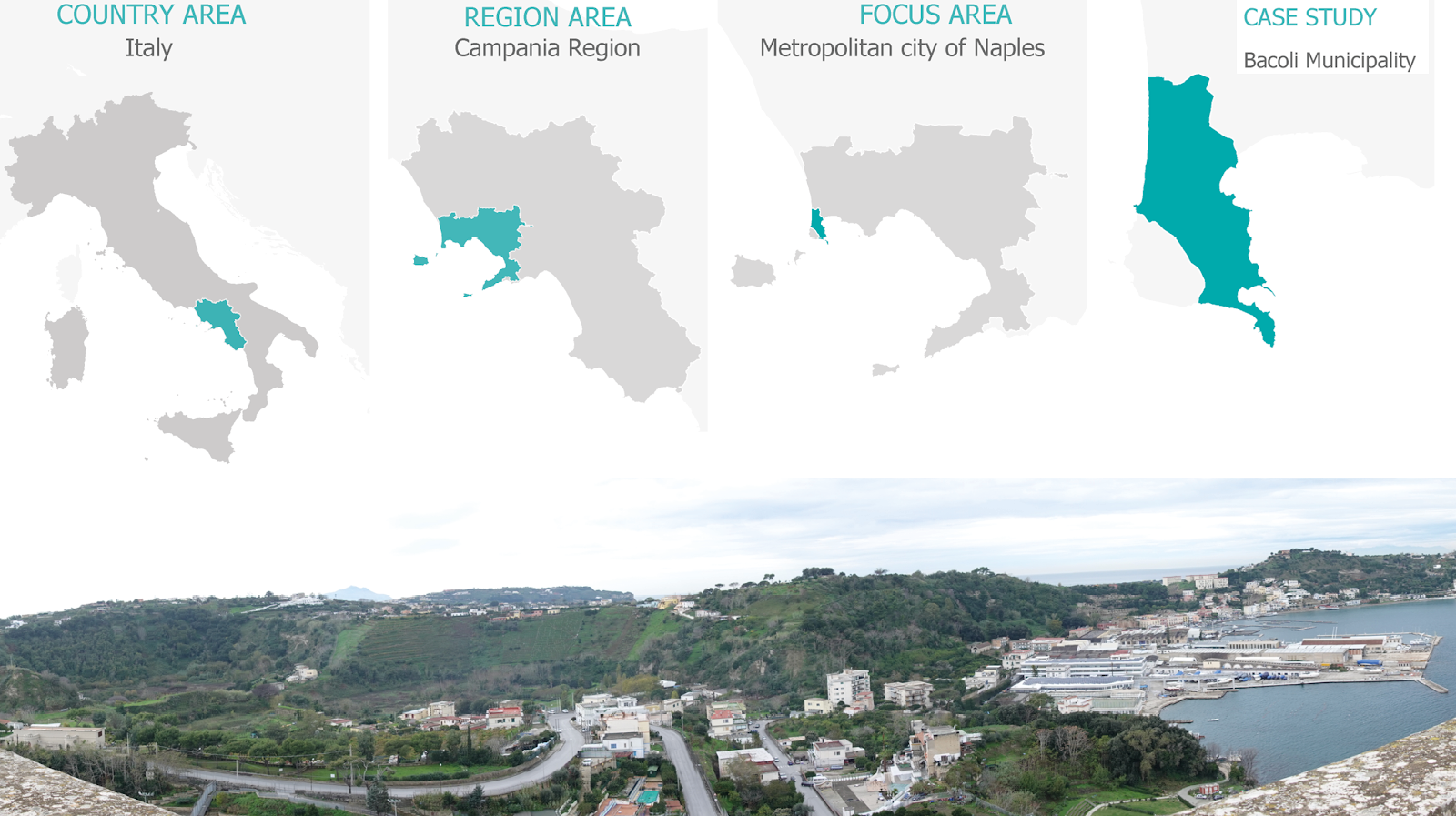
The AOI includes the town of Bacoli (Figure 1) (Table 1) within the Functional Urban Area (FUA) of Naples city (Italy) and it has a surface of approximately 7200 hectares, comprising part of Pozzuoli and Monte di Procida municipalities. The town of Bacoli is featured by a complex landscape system and high intrinsic environmental value, which relate to an inseparable interweaving of natural and anthropic elements, historical urban districts, and agricultural land use. Ancient Roman ruins persist in this town, which was part of a Phlegraean village along with the neighbouring cities of Pozzuoli, Monte di Procida, and Quarto. The urban fabric is characterised by several settlements that have developed over the centuries around pre-existing historic cores characterised by narrow cobbled streets, low houses, and ancient historic buildings, including churches, noble palaces, and Roman and Greek archaeological ruins. Over time, the former landscape systems have determined a complex ecosystem in continuous evolution, but whose fragility appears even more exposed today after the ongoing transformations between the 1960s and 1990s. The natural boundaries of the settlements are shaped by a particular geomorphology, which have been overtaken and partly eroded by an exponential increase in new construction linked to a structured planning design. The planning choices made a new urban fabric arise with the emergence of infrastructure connecting overland and the coast. In particular, the strengthening of capitalist enterprises has generated a change in urbanisation through the construction of large industrial plants and specialised infrastructure. Since then, Bacoli has progressively lost its peculiar identity as well as other Fhlegarean towns.
| Indicator | Value/Description |
|---|---|
| Population | 24,960 residents (Bacoli) (Istat, 2025) |
| Workforce | 9,378 (8,116 employed) (Istat, 2022) |
| Tourist Presence (annual average) | ~150,000 visitors per year (based on regional data) |
| Listed historical/cultural sites | ~47 (Landscape Plan of Campania) |
| Uninhabited buildings (%) | ~23% of total buildings in the AOI (Istat, 2021) |
| Area requiring intervention (%) | ~22% of the AOI surface (based on spatial analysis) |
These interventions have further compromised the landscape and generated places of abandonment. In particular, urban development and, consequently, urban sprawl have changed the area’s morphology, leading over time to the abandonment of urban fabric. Despite their environmental and cultural importance, the Phlegraean area degradation process has accelerated considerably. The imposition of environmental and archaeological constraints in connection with the provisions of the Legislative Decree resulted in the entire territory of Bacoli being declared “of considerable public interest”. However, the area’s geomorphological structure led to urban sprawl and abandonment, especially along the coast and the primary roads at scenic and cultural value points. Despite being strategically located for both land and sea hubs, it continues to show severe infrastructural and landscape degradation, a sign of uncontrolled planning that has scarred the natural and historical landscape and the land morphology.
3.2. A Geodesign-based methodology for regenerating roadscapes
The massive urban transformations that have characterised the city of Bacoli have placed the theme of urban regeneration at the centre of the political debate, as urban, environmental, and social rehabilitation, especially concerning degraded urban areas, makes them fertile ground for new functions. This meaning looks at multiple cultural and design approaches, not necessarily related to regenerative practices, but to a broader definition related to the urban process and thus to urban policy focused on decision-making aimed at the collaborative regeneration of a given context and in which territorial transformations are decided with different stakeholders. Considering degraded urban areas result from economic, social, physical, and environmental transition processes, it is necessary to involve local communities to rethink regeneration strategies.
The engaged stakeholders aim to focus urban development policies on the objectives expressed by the 2030 Agenda, according to which local sustainable development must be inclusive and shared.
Once the decision-making problem was identified, according to the city urban agenda and on-field survey, the methodology was structured considering the issues that emerged from a participatory process with the municipal authority. The focal point was established by referring to:
–outlining strategies shared between the community and stakeholders in a spatially and temporally explicit sphere.
–making the territory qualitatively accessible and liveable;
–fostering the regeneration of degraded contexts referred to as wasted roadscapes.
–implementing interventions related to connectivity and territorial development.
The construction of a collaborative planning process for defining programmatic scenarios of sustainable futures was derived from the shared knowledge, analysis, and evaluation of wasted roadscapes interconnected to all other systems that characterise the territory.
In particular, the methodological proposal was addressed to the use of the Geodesign framework to integrate wasted roadscapes into the decision support tool. The framework has adopted systemic thinking to decision-making problems, by using a dynamic and collaborative process among stakeholders to identify sustainable planning strategies and solutions. The Geodesign framework can be identified as a circular process with the possibility of reiteration in which problem-solving is decomposed into three iterative phases – forward flow, reverse flow and forward flow – consisting of six models that are elaborated for all three steps by answering six specific questions.
The three phases mentioned above (Figure 2) are as follows:
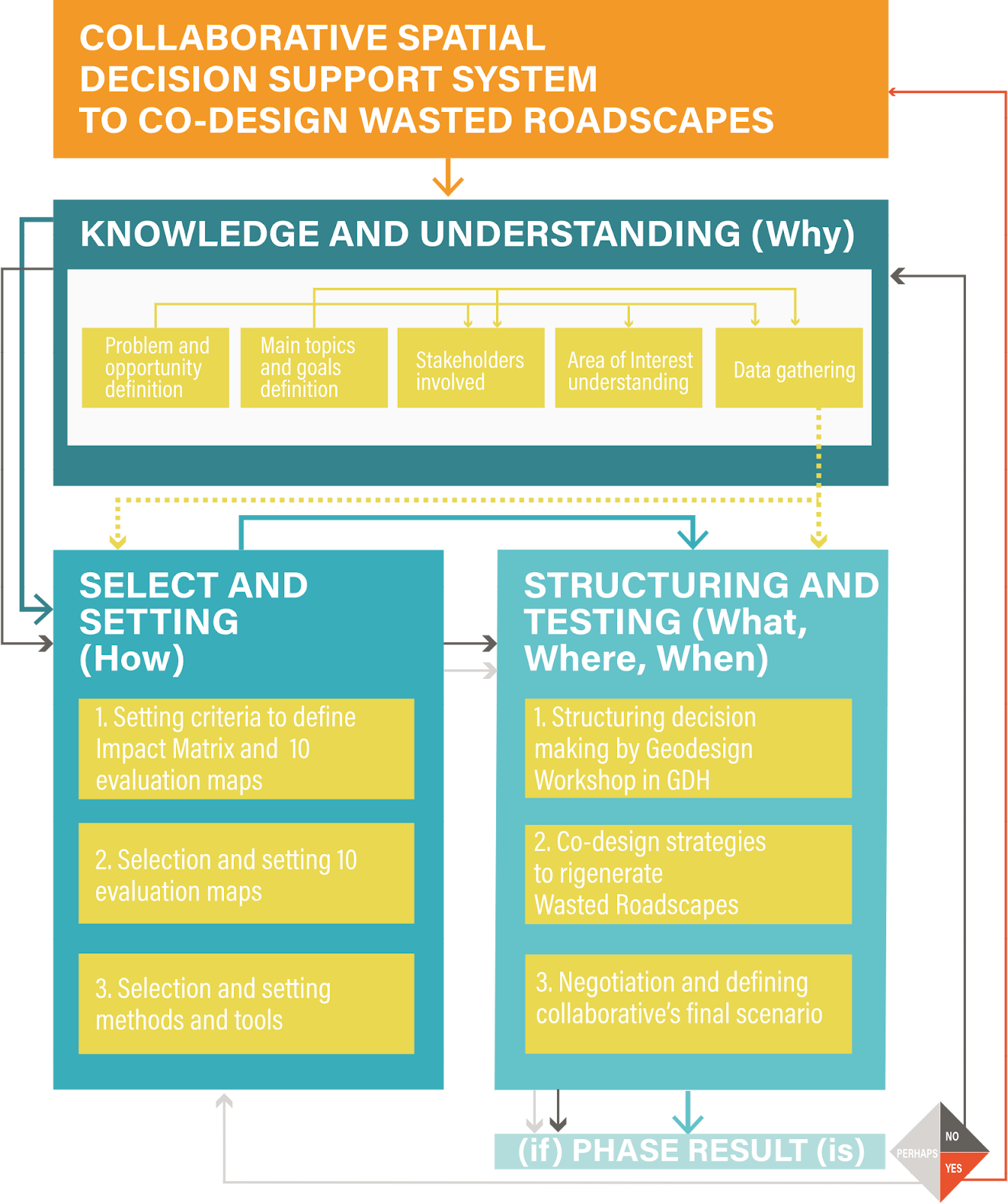
–Knowledge and understanding;
–Selecting and setting;
–Structuring and testing.
The knowledge and understanding phase relates to the framework’s first iteration – referred to as “forward flow (Why)” – and refers to the knowledge and understanding of the AOI, with its problems and opportunities, constraints, and the understanding of concerns through the elicitation of a sharing knowledge about the fundamental objectives. In this phase, the stakeholders involved in the process were also selected.
In the Selecting and setting phase, corresponding to the second iteration – related to “reverse flow (How)” – methods, approaches, and tools were selected to support the decisions. Current plans and projects were analysed, data were collected to construct the database, and criteria were set to generate assessment models for existing conditions.
The Structuring and testing phase was identified with the third iteration – “forward flow (What, Where and When)”- and was addressed to process results produced in the first and second methodological phases. In this phase, the data were organized, spatially represented for the development of the whole project, and shared with all members participating in the process via the GDH platform.
The operational steps were carried out through the involvement of a rich group of people, identified from the public and stakeholders and experts in the field, such as lecturers, researchers, and university students. Furthermore, the entire process was operationalised using spatial analysis tools in ArcGIS Pro, storytelling, shared mapping (Google Mymaps), and the GDH platform, which made all three methodological steps spatially explicit to support the entire collaborative decision-making process. The implemented tools have combined different methods such as simulation models, multi-criteria spatial analysis, visualisation, and data optimisation.
At the same time, the GDH platform, with its simplified interface, has allowed multiple users to provide input and generate output to support spatial decisions during the negotiation phase. The methodological steps were iterated several times, integrating information and data that emerged from meetings with the various actors involved.
The proposed methodology has adhered to Geodesign steps to manage the entire workflow concerning the knowledge, evaluation, and selection of sustainable strategies contextualised to pertinent territorial conditions. The sustainable development of Bacoli was targeted to regenerate the degraded areas linked to the wasted roadscapes through their reconversion to locations serving mobility infrastructures, thereby reconnecting the town without further compromising the landscape. For each of the three methodological phases, performed analyses, implemented methods, and obtained results helped proceed iteratively to establish a collaborative decision-support methodology for evaluating and generating policy and planning scenarios to regenerate wasted roadscapes.
The following subsections 4.1, 4.2, and 4.3 describe the results that rely on applying the methodological framework proposed in Section 3.
4.1. Knowledge and understanding phase
The phase focused on the knowledge of the territorial context in its social, physical, economic, and ecological aspects. Several problems were encountered due to the restrictions imposed by the COVID-19 emergency, which destabilised and reshaped the approach to the case study, considering the possibility of additional data collection tools.
Knowledge of territories was made more comprehensive through field trips, a condition limited by pandemics, which led to the search for additional tools that could quickly lead to knowledge of territory even without direct observation.
Government representatives of Bacoli along with the students of the Master in “Sustainable Planning and Design of Port Areas” from the University of Naples Federico II supported this phase. Within the framework of the master’s course, several activities were organised to support knowledge of the AOI. Current digital tools were used for both social, shared, and collaborative mapping. A social media survey was structured and disseminated with a direct link to the Google Mymaps platform to spatialise some information about the AOI. This made it possible to collect many observations and data valid to explore the territorial context. This information was then implemented through Google Earth and Street View virtual tours and the analysis of the main urban plans. The field survey was carried out at a later stage.
The understanding of the context was based on six questions defined within the Geodesign framework to outline the six representation, process, evaluation, change, impact, and decision models (Steinitz, 2012):
1) How should the context be described?
2) How is the context operating?
3) Is the context working well?
4) How could the context be transformed?
5) What differences can the transformation cause?
6) How should the context be changed?
The first question was referred to the Representation model. The resolution of the decision problem necessitated an extension of the AOI beyond the administrative boundaries to have a broader view, considering possible connections and all potential relationships. In the Geodesign process, different geographical units have been related, including catchment areas, infrastructure networks, landscape networks, and historical networks. Such interrelationships among geographical and urban systems have reduced the possibility of exclusion of certain design risks by improving the results. Conversely, the complexity of the analysis has increased since data with different formats and management systems had to be included for the context analysis. Furthermore, it was necessary to understand whether digital databases accessible on a territorial scale could facilitate the process. In addition, a questionnaire was structured and submitted to local communities and a broader public. The questionnaire and canvas structured on digital and collaborative platforms has allowed a preliminary Living Lab process to be started.
The next phase referred to the Evaluation model concerned with the functioning of the area. In this phase, the social media survey was submitted to citizens and stakeholders via social networks and the Municipality of Bacoli’s website. The questionnaire provided information and data to a direct perception referring to the functional and non-functional aspects of the AOI. The respondents were asked to consider social and spatial elements that help to assess the current conditions, such as the attractiveness of the site for the offered services, presence of facilities, presence or absence of elements of historical-cultural and landscape value, and vulnerability relating to critical areas in environmental and social terms.
Approximately 195 individuals, ranging from 18 to over 65 years, responded to the questionnaire in similar proportions. Among them, 45% were university graduates, and 34% had a high school diploma. Most respondents were employed, with 49% working as employees and 21% as self-employed professionals. A smaller percentage identified themselves as entrepreneurs, students, unemployed, or retired. The participants came from Bacoli and other municipalities in the Campania Region and other locations in Italy, while a small fraction (1%) came from different countries.
In addition to data emerging from the questionnaire and participatory board, it was fundamental to begin identifying and extrapolating from institutional databases the geographic information helpful in understanding the AOI. Thus, The data collected were categorised into natural, social, and economic items, then organised within a searchable digital database named “Geodesign Workshop Oltreporto Miseno” through the ESRI software ArcGis Pro 10.8.
Concerning the Change model, local communities and stakeholders involved during the Living Lab expressed their opinions on possible future transformations through a community canvas structured in the Representation model. In addition, other information was integrated from the questionnaire submitted through the leading social sites. Change can be associated with a positive or negative perception, meaning that if communities are inclined to change, this leads to a better response in proposing ideas, solutions, or judgements. Issues were asked in the questionnaire, and the community canvas as to what changes the area could undergo, whether they were related to increasing land value, creating negative impacts and thus degradation, or conservation or development changes. The emerging picture brought to attention the two main themes identified by the decision-makers as the regeneration of degraded areas and the improvement of the network and infrastructural system. In a smaller percentage, ideas emerged concerning a change in the tourism sector, the re-functioning of coastal areas and the protection and enhancement of the area’s historical, cultural and landscape elements.
After identifying and expressing judgements and possible transformations that could change functional and non-functional aspects, they were asked to explain what kind of impacts these transformations could generate, both positive and negative. The Impact model was outlined not only by referring to the canvas and questionnaire but also by analysing and considering aspects on a legislative basis and thus defined based on technical evaluations of the AOI.
The knowledge phase was completed, defining the decision-making model for implementing the transformations. During this phase, general hypotheses and specific objectives were organised as different information and models emerged from the types of future change.
Specifically, the knowledge and understanding phase included an initial development of future scenarios, outlining the assumptions, objectives, and guiding requirements for the entire process referred to three main strategies:
–Port development;
–Connectivity with neighbouring landscapes;
–Recovery, regeneration, and reclamation of degraded and abandoned landscapes linked to the infrastructure network.
In conclusion, it can be stated that in the cognitive and comprehension phase, it was possible to outline an initial overview of the reference territorial context, in which the diversified points of view defined a business-as-usual scenario with a greater awareness of all critical and potential aspects. The hypothetical scenarios that emerged from the initial scoping phase were helpful in delineating the expectations of local communities for future urban transformation and regeneration processes.
4.2. Selecting and Setting phase
The Selecting and Setting phase have allowed the decision-making model to be structured through a data-driven design by inverting the sequence of the above-mentioned six questions. Digital tools to manage data gathered during the knowledge phase were selected and a suitable process for geographic representation of data was chosen. The Representation model was, thus, structured through data homogenisation by setting unambiguous formatting of qualitative, quantitative, graphical, spatial, and temporal dimensions and criteria.
During this phase, the Decision-making model was compared to the Evaluation model based on the knowledge and perspectives of the different stakeholders involved. It has enlightened relevant issues for the sustainable development of the AOI in terms of recovery and regeneration of wasted roadscapes and enhancement of infrastructural systems both on land and sea. These are the two dominant objectives and requirements which emerged from the consultation phase related to issues concerning: the development of sustainable tourism, enhancement and protection of natural and historical-cultural features, multifunctional urban facilities, reclamation of the main watercourses and water bodies, and technological and energy innovation.
It also emerged that the territory of Bacoli is an open system deeply interconnected with the surroundings and influenced by spatial and temporal sub-systems. For this reason, it was necessary to select leading systems based on International Geodesign Collaboration (IGC) to address the entire decision-making process. In particular, IGC has provided 8 primary and 2 flexible systems related to the study context. The 8 primary systems were established as the most suitable for the AOI with the support of professors Carl Steinitz and Michele Campagna, during the preparation phase of the Geodesign workshop days.
Systems from 1 to 5 – referred to as Water (Water), Agriculture (AGR), Green Infrastructure (GRN), Energy (ENE) and Transport (TRAN) – were selected without changing IGC standard labels, while the Industry and Commerce system was split into two different systems: Commercial activities and functions (COM) and Tourism (INDTUR). In addition, the institutional and residential systems were merged into a single category referred to as Mixed-use (MIX), and Cultural Heritage (CULT) was selected to better represent complex territorial values linked to material and immaterial heritage. Finally, the tenth system – denominated Reclaim (RCLM) – was chosen to include wasted roadscapes as relevant landscape features to be considered for the development trajectories of Bacoli (Figure 3).
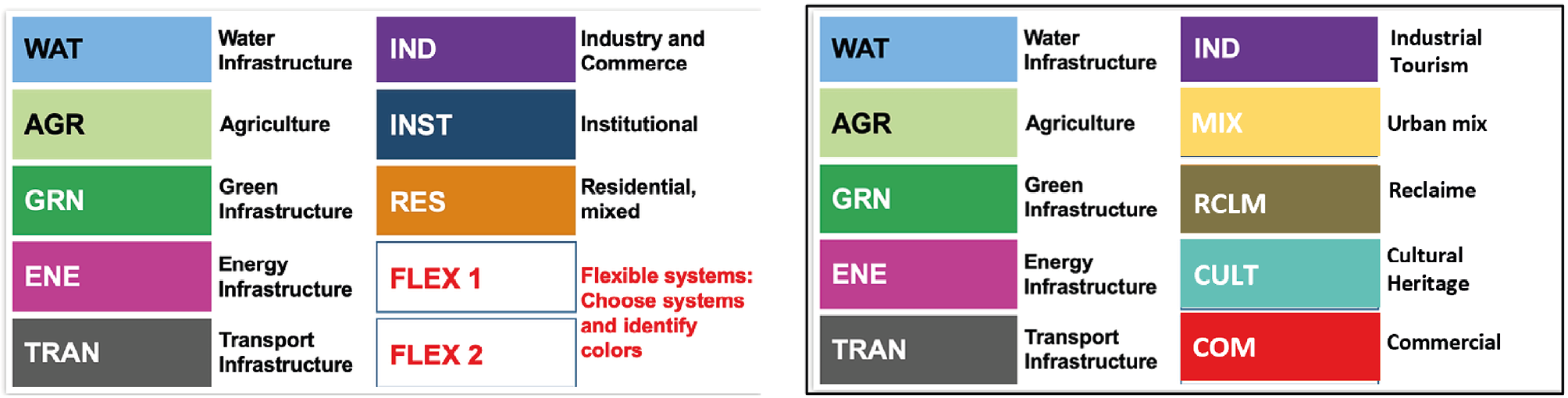
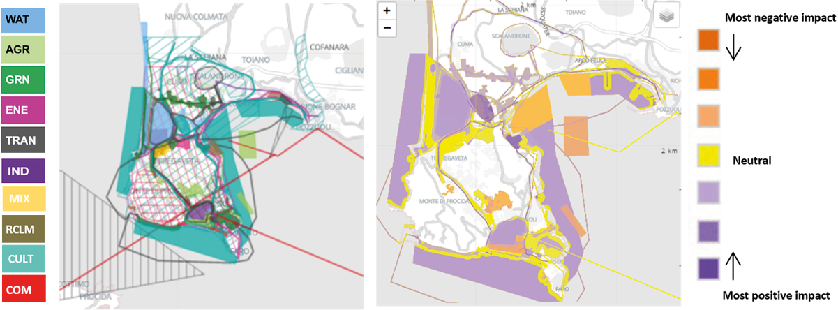
The ten systems were, thus, classified as vulnerable to change (WAT, AGR and GRN) and attractive to change (ENE, TRAN, INDTOUR, MIX, RCLM, CULT and COM). Afterwards, a five-class impact matrix (Figure 4) was filled in GeodesignHub through a numerical scale ranging from highly positive (+2: dark purple) to very negative (-2: orange) to summarise the potential impacts concerning the ten systems in a collaborative environment. In addition, the cross-system Impact model dynamically modifies and updates the assessment model as the projects are developed. Using the Impact matrix, the platform estimates the project’s implications and displays the number of interconnected systems (Somma et al., 2022).
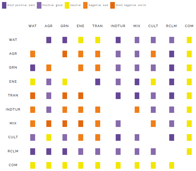
The selection of a 5-point scale in both the impact matrix and evaluation maps was made for its balance between detail and ease of understanding. This scale is often implemented in collaborative platforms such as Geodesignhub to facilitate stakeholder discussions and prevent participants from being overloaded by reducing cognitive gaps. Such approaches have been validated in literature (Campagna et al., 2016; Somma et al., 2022), as they foster useful classification and support consensus-building in participatory processes.
The Change model was determined concerning the users’ point of view so that strategies and solutions have been defined democratically. In the next stage, evaluation criteria were set concerning each system to build the Evaluation model, which was inferred from the Decision-making model and, concurrently, has affected the Change model, by addressing different solutions e.g. reservoirs protection, nature conservation, heritage valorisation or transformation of built environment. Criteria and attached values underlying the Evaluation model refer to different variables expressing positive (attractiveness) or negative (vulnerability) characteristics of the territory.
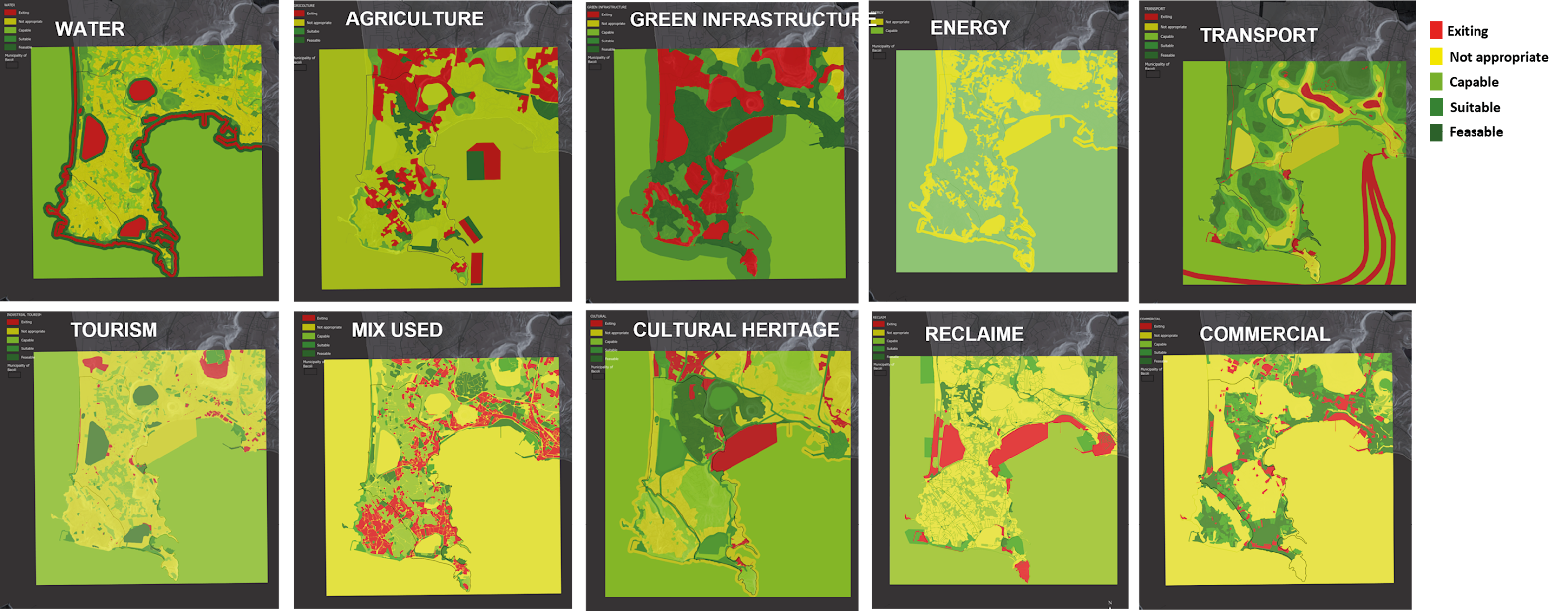
The evaluation criteria were categorised into five levels of likely transformations, represented through 10 choropleth maps with the following coloured labels:
–Dark green (Feasible), indicating the highest feasibility for change, as there are prerequisites for new projects;
–Green (Suitable), denoting suitability for transformation, as the area already has technologies that support the project;
–Light green (Capable), suggesting transformations are possible given the economic means to support interventions;
–Yellow (Not appropriate), indicating areas where changes are inappropriate;
–Red (Existing), representing areas already in a healthy state where the system should not be compromised.
Each system’s reference database was processed using GIS spatial analysis tools and on-field knowledge. After setting variables according to IGC standards, the five eligibility conditions were determined to create the evaluation maps. The reference database used to build these maps comprised information from stakeholder meetings, shared online mapping (Figure 6), and official databases.
All layers were organised, starting from red and gradually combining the different groups to dark green. A Python script for automatic data processing on Urban Atlas and Corine Land Cover maps was implemented to design the ENE and MIX systems.
A short description of IGC primary systems maps follows to explain the rationale at the foundation of the Evaluation model.
Potential actions linked to the WAT system included interventions at lake mouths to restore and improve water exchange in the lake/sea system and to upgrade the hydraulic banks of streams and lakes.
The AGR system focused on fostering growth and efficiency in regional food production. New businesses, brands, circuits, and structures geared towards a market – not just local but also capable of attracting visitors interested in learning about the local production chain – are expected to emerge from the system’s activities.
The GRN system aims to conserve and develop landscape, environmental, coastal, and economic productivity. By connecting places of high naturalistic value and ensuring sustainable use of the terrain and its resources, this system promotes the development of green infrastructures.
Tourism infrastructure and services were derived from the INDTUR system. This system plans to implement measures to preserve and expand the availability of cultural and natural assets, tourism attractions, and services to increase host capacity and lodging options. Possible actions include enhancing accommodation offerings, expanding services, activities, and attractions for tourists, promoting ecotourism that conserves and enhances the area, and enhancing thermal areas. Measures for the INDTUR system ensure the long-term sustainability of the CULT, MIX, and COM systems, which aim to improve the local commercial sector and neighbourhood commerce while implementing services related to these activities.
The CULT system is aimed at promoting interventions for the restoration, securing, and maintenance of abandoned places, the removal of landscape and environmental detractors, the removal of architectural barriers, and actions for the recovery of museum collections, architectural, archaeological, and industrial archaeology.
The ENE system seeks to achieve lower consumer prices by promoting sustainable energy efficiency. One of the most at-risk yet crucial to the region’s long-term prosperity is the RCLM system (Table 2), including regeneration treatments, requalification, and recovery treatments for the circular economy. Possible actions may include the regeneration of degraded rural landscapes, the recovery of biodiversity in dune systems, the regeneration of interstitial areas of road infrastructures, the recovery of polluted water, the adaptive reuse of buildings, the innovative rehabilitation of unauthorised or dilapidated buildings, and the redevelopment of industrial and military archaeological sites.
| Dimension | System | Reclaim System’s analysis | |
|---|---|---|---|
| General Variable | Variable | ||
| D1. Social and Cultural Function | S1. Urban | U1. Urban space | 1. Abandoned Port area 2. Unlawful dumps |
| U2. Building and Settlement | 1. Settlement in crisis 2. Empty or occupied dwelling 3. Unlawful buildings 4. Potentially contaminated sites |
||
| D2. Environmental | S2. Landscape | L1. Soil | 1. Protect area 2. Area without current destination 3. Volcanic Risk Area 4. Landslide risk area 5. Fallow areas and urban soils 6. Disused quarried 7. Unlawful quarries |
| L2. Water | 1. Contaminated water 2. Areas with high hydraulic risk 3. Closed bathing areas |
||
| D3. Service | S3. Infrastructure | T1. Road and railway network | 1. Abandoned infrastructure 2. Interstitial buffer zone 3. Abandoned bus and metro station |
| T2. Coast area | 1. Abandoned port area | ||
The TRAN system (Table 3) was considered crucial for planning direct interventions in road construction, hubs, and mobility routes to facilitate the movement of people and products by reducing traffic congestion. A spatial database with layers of road, rail, and sea road infrastructure, parking lots, ports and recreational areas, and public transportation stops supported the definition of the transportation-related assessment map.
| Dimension | System | Transport System’s analysis | |
|---|---|---|---|
| General Variable | Variable | ||
| D1. Social and Cultural Function | S1. Urban | U1. Urban space | 1. Port area 2. Staging area 3. Stopover 4. InfoPoint 5. Mobility hub 6. Dismissed infrastructure |
| D2. Environmental | S2. Landscape | L1. Landslide | 1. Landslide hazard |
| L2. Land | 2. Use of land and urban land | ||
| L3. Coast | 3. Coast erosion | ||
| L4. Landscape | 4. Protected landscapes | ||
| D3. Service | S3. Infrastructure | T1. Road network | 1. Length of road network (in km) 2. Road network density(m/km2) 3. Speed limits 4. Travel times 5. Cycle path (in km) |
| T2. Railway network | 6. Railway network (in km) 1. Railway network density (km/ km2) 2. Frequency services 3. Number of railway and metro station |
||
| T3. Road Network/ UAtlas Railway Network/UAtlas |
1. Capillarity value 2. Accessibility degree 3. Centrality value |
||
| T4. Maritime network | 1. Average travel times 2. Number of Maritime’s lines |
||
| T5. Parking/Urban Atlas | 1. Capacity of parking spaces 2. Accessibility degree 3. Centrality value |
||
| T6. Port area/Urban Atlas | 1. Number of ports 2. Accessibility degree 3. Centrality value |
||
| T7. Bus stops/Urban Atlas | 1. Number of buses stop 2. Centrality value 3. Number of lines |
||
The ten evaluation maps supported the choice of policy and project diagrams. A comprehensive list of data and criteria used to build the evaluation maps related to Reclaim (RCLM) and Transportation (TRAN) systems is provided by the authors in Tables 2-3 and the spatial maps in Figure 5 show the spatial representation of landscape systems for all the aforementioned systems.
4.3. Structuring and testing phase
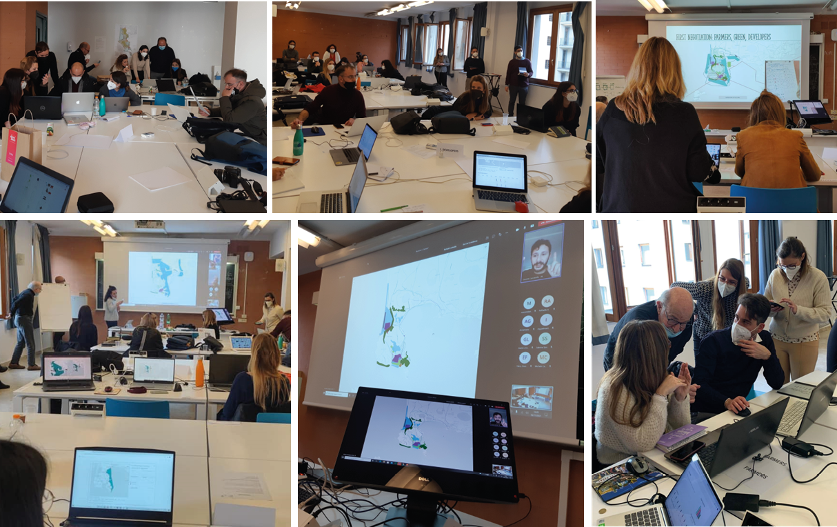
In this phase, the Hybrid Geodesign workshop – held in November 2021 at the Department of Architecture of Naples (Italy) – was organised with the participation of 35 people, including academics with different affiliations, as well as public administration employees from Bacoli, private sector representatives, and other stakeholders (Figure 6). The participants were selected as experts in the fields of engineering, architecture, urban planning, GIS, Information Science and Technology to stimulate different perspectives for changing scenarios. Most of the participants had their first experience with the territory, and some people attended live streams of the workshop sessions online.
All data collected in the previous iterations were gathered and organised into the GDH platform to allow people to co-design sustainable development projects or policies through digital sketches. The Representation, Process, and Evaluation models were pre-processed during a seven-month pre-workshop phase, while the Change, Impact, and Decision models were produced by participants in a 5-days workshop session. The first two days were focused on a further survey of the AOI and the setting of the entire process to allow participants to practise the operational steps within the GDH platform. On the third day, the evaluation maps were presented by the coordination team as a knowledge base to start the design.
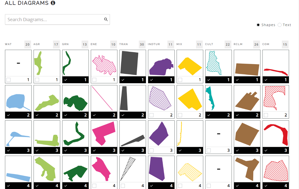
Before organising the design groups, the organisers assigned an evaluation map to each of the participants and were required to draw five projects and policy diagrams, including the IGC System Innovations (https://www.igc-Geodesign.org/global-systems-research). The sketched diagrams were, thus, completed with three requirements concerning: the type of funding (public or private), information about the geographical entity (linear or polygonal), and the solution budget estimated. The platform gathered approximately 175 diagrams depicting policies or projects for each of the ten systems (Figure 7). After this step, the participants were divided into six groups of stakeholders with specific roles in the decision-making process, as shown in Table 4.
| Number group | Group of stakeholders | |
|---|---|---|
| Name of Group | Acronyms | |
| 1 | Metropolitan administrators | METRO |
| 2 | Cultural heritage conservation | CULT |
| 3 | Developers | DEVE |
| 4 | Tourism | TOUR |
| 5 | Green | GREEN |
| 6 | Farmers | FARM |
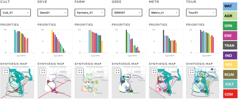
The evaluation models built in the second iteration were entered into the GDH, allowing the different groups to evaluate ex-ante and ex-post impacts according to proposed solutions. The six working groups, playing a role in the planning process, defined their priorities by assigning each system a value from 1 (low priority) to 10 (high priority), with the possibility of reviewing, modifying, or drawing new diagrams. Afterwards, each group was asked to select project proposals close to their interests to compose a scenario that would meet the required objectives to be presented later to other teams. This phase led to the construction of 12 scenarios, divided into 6 scenarios per two iterative steps (Figure 8, Figure 9).
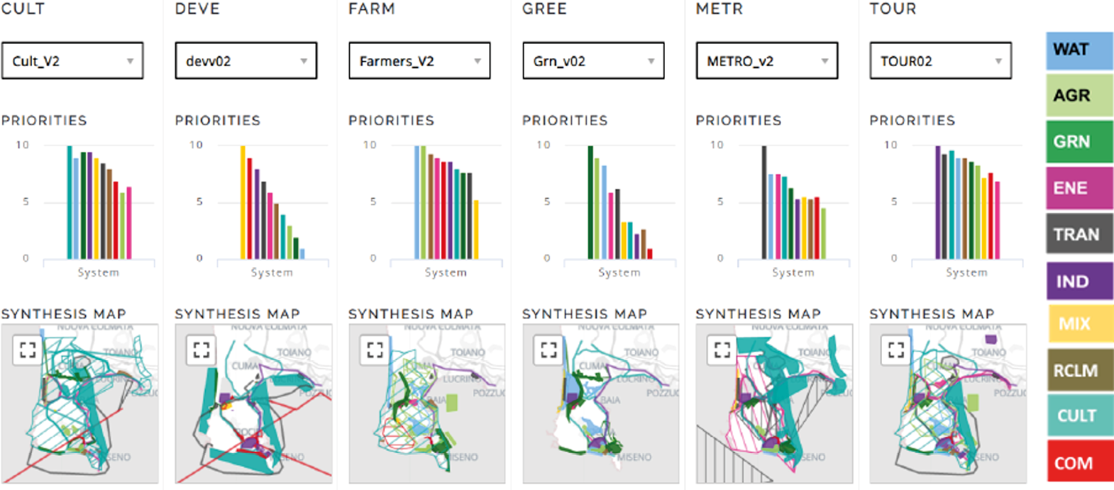
For each phase, an impact assessment of the proposed scenarios, evaluated concerning the target objectives for the AOI transformations, was designed to identify weak points and revise choices by selecting those that minimise negative impacts and reduce implementation costs. In the second iteration, many design proposals changed so significantly that some team members eliminated diagrams to mitigate negative impacts and costs, while others were implemented.
Through two negotiation rounds, the final output of the process comprised the collaborative design of an overall scenario. The similarities between the six stakeholder groups’ different solutions were identified using a sociogram. Each team leader was asked to set his or her preference about other groups’ scenarios through a qualitative scale ranging from “very negative” to “very positive”. The interpretation of results allowed two coalitions to be determined, including:
–Tourism, Culture, Metropolitan Team (TCM)
–Green, Developers, Farmers Team (GDF)
During the first round of negotiations, the two coalitions developed a complementary synthesis of their meta-planning design, through mutual discussion and compromises. A frequency diagram has facilitated the comparison of the scenarios proposed by the two stakeholder groups (TCM and GDF), allowing design similarities to emerge through a simplified negotiation process. After the presentation of the two revised scenarios, a final step lets compatible policies and projects converge into a shared scenario envisioned by 2030 to address the goals established for the AOI during the preparatory stages.
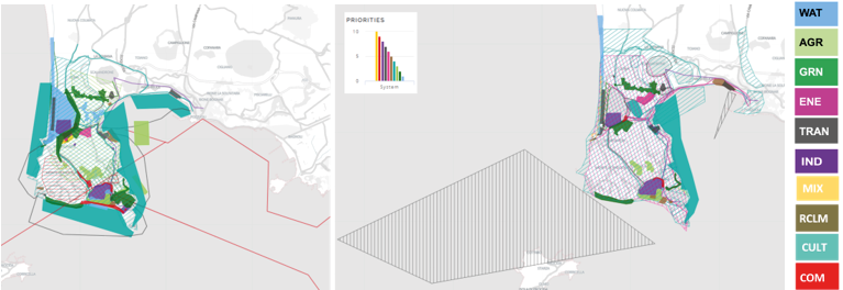
In particular, the scenario proposed by the TCM team (Figure 10a) highlights many solutions aimed at solving the problem of connectivity from land and sea, and brownfield rehabilitation, giving less importance to the design and policy interventions planned for the WAT, AGR, GRN, ENE, INDTUR, MIX and COM systems. The scenario approved by the GDF team (Figure 10b), selecting a more significant number of design interventions for the WAT, AGR, GRN, INDTUR, COM and CULT systems, produces few interventions for the MIX, ENE, and TRAN systems. The two scenarios, therefore, turn out to be almost entirely different. However, negotiation and collaboration facilitated the construction of the overall scenario (Figure 11a) with its relative impacts on the city (Figure 11b). This scenario was compounded by 123 selected diagrams comprising 88 surfaces and 35 linear paths.
The results prioritise the transport system, followed by cultural and recovery systems. Among the 13 actions identified within the RCLM system, seven actions were related to the three types of wasted roadscapes WRsc, WRes, and WRhub:
–Enhancement and recovery of the Roman theatre and baths area.
–Redevelopment of the theatre compendium area.
–Regeneration of stagnant water and enhancement of the thermal water springs.
–Reclamation of marine waters and hydrographic network.
–Reconversion of the former Pozzuoli shipyards.
–Re-functioning of Miseno military areas.
–Regeneration of the former “Mericraft area”.
The implementation of the RCLM system in the Geodesign process will give decision-makers a wide vision to take into consideration actions of regeneration that interact with other systems of the urban environment. However, aside from the technical and strategic features, the designed projects were expected to deliver valuable services to residents, workers, and visitors in the area of Bacoli.
In particular, local residents benefit from the transformation of abandoned or underused spaces that offer a renewed sense of belonging. A safer, cleaner, and more welcoming environment can improve daily life, whether it’s through the enjoyment of a revitalised waterfront, or a restored cultural site. The regeneration of historical landmarks, like the Roman theatre and thermal baths, helps reconnect the community with its cultural roots, while also drawing in visitors to participate in local business within an enabling context.
These projects spark opportunities across a range of sectors – from construction and environmental remediation to heritage preservation, hospitality, and tourism. Here, given that part of the neighbourhood stands on former shipyards or former military zones, the potential for economic reactivation is considerable. Visitors experience a more immersive and interactive destination with improved environmental quality, renewed historical sites, and diversified experience, e.g. wellness tourism around the thermal springs and cultural itineraries through restored archaeological sites.
Introducing the RCLM system within the Geodesign process led decision-makers to be informed about the possibility of envisaging regeneration actions connected to other systems. Exploring these interacting systems through an integrated approach helped figure out Bacoli as a multifunctional landscape, with the potential of reaching global sustainability objectives and boosting the resilience of environmental and cultural systems.
The Geodesign framework, through the GDH platform, has facilitated the swift resolution of complex issues, increased participants’ knowledge, and fostered consensus-building. Geodesign has engaged participants in simultaneously comparing the impacts of different solutions and has empowered stakeholders to choose planning strategies that meet spatial and social requirements while minimising trade-offs.
The inclusion of wasted roadscapes in the Geodesign process presents both potential and limitations essential for sustainable urban planning and regenerating degraded areas. Firstly, Geodesign recognises the potential of wasted roadscapes as resources that can be restored and reused sustainably. This perspective reframes these areas from problems to opportunities for transformation and improvement. It has provided a platform for developing specific strategies for urban regeneration tailored to wasted roadscapes, transforming them into vibrant and functional spaces for the local community. This can revitalise degraded areas and enhance the quality of life for residents and workers.
Additionally, the Geodesign process facilitates impact assessment arising from different planning strategies and policies on the regeneration of abandoned landscapes, allowing for the selection of the most sustainable solutions by balancing diverse objectives such as environmental conservation, mitigation of negative social impacts, and enhancement of the built environment’s quality. Furthermore, Geodesign fosters active stakeholder engagement, enabling inclusive participation and a better understanding of local needs. This involvement ensures more acceptable and sustainable outcomes by incorporating diverse perspectives and local knowledge.
Regarding the overall workshop experience, one limitation is the time required to ensure the project’s accuracy. This method is most effective in strategic planning and establishes a solid foundation of consensus for constructing urban and spatial plans, followed by subsequent executive design phases. Additionally, the hybrid workshop presented challenges as it involved people who speak different languages and have different backgrounds, skills, and expertise. This necessitates the use of multiple online collaboration tools that support the entire process and can manage possible conflicts, improving the enabling conditions for dialogue and cooperation. Tools such as Miro, MyMaps, and Microsoft Teams were employed during the workshop to facilitate stakeholder interaction.
For the addressed case study, several days were needed to identify additional schemes to involve local communities, including citizens of different ages and roles with varying knowledge. Despite organising local knowledge days before the workshop, they proved insufficient to complete the process, although several strategic scenarios promoting sustainability emerged.
However, despite the potential benefits, including wasted roadscapes in the Geodesign process also entails certain limitations that must be addressed. Firstly, analysing wasted roadscapes can be complex, requiring detailed and comprehensive data to assess current conditions and potential regeneration options. This complexity adds challenges to the Geodesign process and necessitates meticulous planning. Secondly, assessing the environmental, social, and economic impacts of regenerating abandoned landscapes can be challenging, particularly locally, since the interactions among systems and associated uncertainties make comprehensive impact assessment difficult. Lastly, successful landscape regeneration necessitates adequate financial resources and careful planning. Insufficient funding and resources can limit the effectiveness of proposed solutions and prevent their implementation.
Despite the broad stakeholder involvement achieved during the planning and design phases, some limitations emerged regarding the representation of specific social categories. Groups that are often at risk of exclusion – such as youth, the elderly, and migrant communities – were only marginally involved or underrepresented in the participatory sessions.
This presents a wider issue in the field of spatial planning processes where institutional actors and technical experts retain the level of control and management, while neglecting the lived experiences and needs of more vulnerable communities. As we consider the potential applications for Geodesign in Bacoli, it’s reasonable to expect we can build on – and with – local knowledge. In Bacoli, it is essential to design a more inclusive approach and consider how explicitly to engage the vulnerable communities to be involved in the process. For example, building a workshop that engages people on their own terms; designing a communication tool they can relate to; holding workshops on accessible locales; and working with third-sector organizations and local NGOs who have access and existing relationships with these neighborhoods can only enhance the level of engagement and participation. From this perspective, a positive impact on the planning process through the inclusion of further viewpoints, values, and localized knowledge has been expected. Geodesign supports decision making and strategic planning in collaborative settings to activate consensus building among several divergent actors. Nevertheless, a key aspect worth mentioning and considering further is how to improve the sustainability and maintenance of newly regenerated places going forward. Although the methodology is highly effective in framing collaborative visions and guiding spatial transformation strategies, the long-term maintenance strategy of the achieved outcomes remains a key challenge, which should be integrated in the intervention costs.
In summary, including wasted roadscapes in the Geodesign process offers substantial potential for urban regeneration and sustainable planning. However, it is crucial to address the limitations, including accurate analysis, stakeholder engagement, impact assessment, and availability of adequate resources, to ensure successful and effective initiatives.
The article showed a collaborative spatial decision support system (C-SDSS) to include wasted roadscapes in the Geodesign framework to boost adaptive urban planning and regeneration strategies.
This study represents a further step towards including abandoned roadscapes in strategic and sustainable planning processes, as the treatment of abandoned landscapes involves an approach to urban development minimising land consumption. The proposed methodology explicitly highlighted the potential of the Geodesign process to support collaborative decision-making in the definition of sustainable strategies, facing the challenges of evaluating abandoned landscapes through the Impact model and their interpretation through the Representation model.
Two Research Questions (RQ) were identified at the foundation of this study to stress the potentials and limitations of a Geodesign-based approach, testing the methodological workflow in a real-world case study, and considering further applications to implement a collaborative and spatial decision support system.
The RQ1 was addressed to explore solutions to bridge the gap of traditional planning processes which struggle with wicked problems of urban regeneration, exploring new evaluation methods for wasted roadscapes and integrating these topics into planning strategies. The methodological approach and its implementation highlighted how wasted roadscapes can be included in a Geodesign process, defining a new perspective that considers them as resources for a sustainable local strategy. Indeed, the final design projects and policies focused on developing a network of multi-level connections by regenerating wasted roadscapes. In addition, different interventions were selected to enhance the AOI, including the reclamation and regeneration of wasted roadscapes.
The lesson learned by the experimented Geodesign process to include roadscape in planning strategies relates to RQ2. Wide considerations can be made from the overall process, but three specific points emerged from the Geodesign Workshop for Bacoli:
–The significant support of the Geodesign-based decision support system in focusing attention on degraded roadscapes and abandoned landscapes (i), changing the perspective from weakness points to opportunities.
–The strong engagement of local communities and stakeholders, practitioners, and experts which internalised the topic of roadscapes and designed integrated solutions to deal with it.
–The democratisation of decisions and the effectiveness in managing conflicts that arose during the consultation phase about the role of roadscapes in regeneration strategies.
The proposed approach facilitated the development of multiple alternative scenarios for Bacoli’s territorial strategies, promoting consensus through negotiation and reducing the number of projects into two overall meta-planning strategies.
Governing models that define responsibilities for the ongoing upkeep, modification, and management of the enhanced areas are equally important. The definition of more effective post-implementation assessment processes that incorporate social, spatial, and economic action as well as monitoring sustainability of interventions represents future research pathways and practical implementations of Geodesign for Bacoli. In addition, these models should incorporate public and private partnerships, community-based stewardship, and other mixed participatory approaches that guarantee ongoing sustained funding and engagement from various sectors. Their integration can allow altered regions to adapt dynamically over time to emerging needs and conditions, thereby protecting the social and spatial value created through the initial developmental design.
In conclusion, collaborative spatial decision support systems implemented with Geodesign-based approaches represent a fundamental element for integrating sustainability in city planning and multidimensional impacts assessment. C-SDSS set connections between integrated evaluation methods and co-planning tools to collaboratively gather data, assess potential impacts on the territory, and choose preferable solutions. Concurrently, the regeneration of wasted roadscapes activates a chain of processes to reclaim compromised spaces and enhance sustainability levels of spatial decision-making.
Arciniegas, G., Šileryté, R., Dąbrowski, M., Wandl, A., Dukai, B., Bohnet, M., & Gutsche, J. M. (2019). A geodesign decision support environment for integrating management of resource flows in spatial planning. Urban Planning, 4(3), 32–51. https://doi.org/10.17645/UP.V4I3.2173
Athanassiou, E. (2023). Participation as a Global Urban Strategy Towards Resilience. The Journal of Public Space, 8(3), 45–60. https://doi.org/10.32891/JPS.V8I3.1199
Attardi, R., Bonifazi, A., & Torre, C. M. (2012). Evaluating sustainability and democracy in the development of industrial port cities: some Italian cases. Sustainability, 4(11), 3042–3065. https://doi.org/10.3390/SU4113042
Ballal, H. (2015). Collaborative Planning with Digital Design Synthesis. Doctoral dissertation, University College London (UCL).
Batty, M. (2009). Cities as complex systems: scaling, interaction, networks, dynamics and urban morphologies. In Meyers, R. A. (Ed.). Encyclopedia of Complexity and Systems Science. New York, Springer, 1041–1071. https://doi.org/10.1007/978-0-387-30440-3_69
Brinkerhoff, D. W., & Wetterberg, A. (2016). Gauging the effects of social accountability on services, governance, and citizen empowerment. Public Administration Review, 76(2), 274–286. https://doi.org/10.1111/PUAR.12399
Campagna, M., Steinitz, C., Di Cesare, E. A., Cocco, C., Ballal, H., & Canfield, T. (2016). Collaboration in planning: the Geodesign approach. Rozwój Regionalny i Polityka Regionalna, 35, 55–72. https://pressto.amu.edu.pl/index.php/rrpr/article/view/8574/8446
Cecchini, M., Zambon, I., Pontrandolfi, A., Turco, R., Colantoni, A., Mavrakis, A., & Salvati, L. (2019). Urban sprawl and the ‘olive’ landscape: sustainable land management for ‘crisis’ cities. GeoJournal, 84(1), 237–255. https://doi.org/10.1007/S10708-018-9848-5/FIGURES/4
Cerreta, M., Mazzarella, C., & Somma, M. (2020a). Opportunities and Challenges of a Geodesign Based Platform for Waste Management in the Circular Economy Perspective. Lecture Notes in Computer Science (Including Subseries Lecture Notes in Artificial Intelligence and Lecture Notes in Bioinformatics), 12252 LNCS, 317–331. https://doi.org/10.1007/978-3-030-58811-3_23/FIGURES/8
Cerreta, M., Poli, G., & Reitano, M. (2020b). Evaluating Socio-spatial Exclusion: Local Spatial Indices of Segregation and Isolation in Naples (Italy). Lecture Notes in Computer Science (Including Subseries Lecture Notes in Artificial Intelligence and Lecture Notes in Bioinformatics), 12253, 207–220. https://doi.org/10.1007/978-3-030-58814-4_15
Cocco, C., Jankowski, P., & Campagna, M. (2019). An analytic approach to understanding process dynamics in geodesign studies. Sustainability, 11(18), 4999. https://doi.org/10.3390/SU11184999
Duvernoy, I., Zambon, I., Sateriano, A., & Salvati, L. (2018). Pictures from the other side of the fringe: urban growth and peri-urban agriculture in a post-industrial city (Toulouse, France). Journal of Rural Studies, 57, 25–35. https://doi.org/10.1016/J.JRURSTUD.2017.10.007
Elliot, T., Goldstein, B., Gómez-Baggethun, E., Proença, V., & Rugani, B. (2022). Ecosystem service deficits of European cities. Science of The Total Environment, 837, 155875. https://doi.org/https://doi.org/10.1016/j.scitotenv.2022.155875
Elmqvist, T., Bai, X., Frantzeskaki, N., Griffith, C., Maddox, D., McPhearson, T., Parnell, S., Romero-Lankao, P., Simon, D., & Watkins, M. (2018). Urban planet: knowledge towards sustainable cities. Cambridge, Cambridge University Press.
Esposito, D., Zanin, G. M., Balena, P., & Monno, V. (2024). Achieving SDGs through Public Participation in Spatial Planning and Urban Governance: International Standards for Effective Implementation. In Marucci, A., Zullo, F., Fiorini, L., & Saganeiti, L. (Eds.). Innovation in Urban and Regional Planning. Cham, Springer Nature Switzerland, 396–407.
Fregolent, L., & Tonin, S. (2016). Local public spending and urban sprawl: analysis of this relationship in the Veneto region of Italy. Journal of Urban Planning and Development, 142(3), 05016001. https://doi.org/10.1061/(ASCE)UP.1943-5444.0000318
Irvin, R. A., & Stansbury, J. (2004). Citizen participation in decision making: is it worth the effort? Public Administration Review, 64(1), 55–65. https://doi.org/10.1111/J.1540-6210.2004.00346.X
Koolhaas, R. (2006). Junkspace. Per un ripensamento radicale dello spazio urbano. Macerata, Quodlibet.
Lami, I. M., & White, L. (2022). Are psms relevant in a digital age? Towards an ethical dimension. In Salhi, S., & Boylan, J. (Eds). The Palgrave Handbook of Operations Research. Cham, Palgrave Macmillan.781–801. https://doi.org/10.1007/978-3-030-96935-6_24/FIGURES/3
Marin, J., & De Meulder, B. (2018). Interpreting circularity. Circular city representations concealing transition drivers. Sustainability, 10(5), 1310. https://doi.org/10.3390/SU10051310
Medina, C. D., & Monclús, J. (2018). Urban Visions: From Planning Culture to Landscape Urbanism. Cham, Springer.
Hall, C. M. (2013). The ecological and environmental significance of urban wastelands and drosscapes. In Zapata, M. J., & Hall, C. M. (Eds.). Organising waste in the city: international perspectives on narratives and practices. Bristol, UK, Policy Press, 21–40. https://doi.org/10.46692/9781447306382.002
Newman, G., Park, Y., Bowman, A. O. M., & Lee, R. J. (2018). Vacant urban areas: causes and interconnected factors. Cities, 72, 421–429. https://doi.org/https://doi.org/10.1016/j.cities.2017.10.005
Nyerges, T., Ballal, H., Steinitz, C., Canfield, T., Roderick, M., Ritzman, J., & Thanatemaneerat, W. (2016). Geodesign dynamics for sustainable urban watershed development. Sustainable Cities and Society, 25, 13–24. https://doi.org/10.1016/J.SCS.2016.04.016
Raffestin, C. (2003). Immagini e identità territoriali. In Dematteis, G., & Ferlaino, F. (Eds.). Il Mondo E I Luoghi: Geografie Delle Identità E Del Cambiamento. IRES, Torino. 3–11. Available at: https://www.byterfly.eu/islandora/object/librib:363225/datastream/PDF/content/librib_363225.pdf (Accessed 1 December 2024).
Roggema, R. E., van den Dobbelsteen, A. A. J. F., Biggs, C., & Timmermans, W. (2011). Planning for climate change or: How wicked problems shape the new paradigm of swarm planning. WPSC 2011: 3rd World Planning Schools Congress, Perth, Australia, 4-8 July 2011. Available at: https://repository.tudelft.nl/islandora/object/uuid%3A96fb3d16-f94e-4e9f-a80a-6ff648c3309d (Accessed 1 December 2024).
Russo, M., Amenta, L., Attademo, A., Cerreta, M., Formato, E., Remøy, H., van der Leer, J., Varjú, V., & Arciniegas Lopez, G. (2017). REPAiR: REsource Management in Peri-urban AReas: Going Beyond Urban Metabolism | TU Delft Repository. Available at: https://repository.tudelft.nl/record/uuid:e23a0980-558b-4963-ab1e-13e139867de1 (Accessed 1 December 2024).
Somma M. (2022). CoDeSs – Collaborative Decision Support System in Spatial Planning. Method and tools to sustainable evaluated and co-design wasted roadscapes. PhD Thesis. University of Naples Federico II.
Somma, M., Campagna, M., Canfield, T., Cerreta, M., Poli, G., & Steinitz, C. (2022). Collaborative and sustainable strategies through geodesign: the case study of Bacoli. Lecture Notes in Computer Science (Including Subseries Lecture Notes in Artificial Intelligence and Lecture Notes in Bioinformatics), 13379 LNCS, 210–224. https://doi.org/10.1007/978-3-031-10545-6_15/FIGURES/9
Steinitz, C. (2012). A framework for geodesign: changing geography by design. Redlands, ESRI Press. https://books.google.com/books/about/A_Framework_for_Geodesign.html?hl=it&id=aF-J7WujMxQC
Sydelko, P., Midgley, G., & Espinosa, A. (2021). Designing interagency responses to wicked problems: creating a common, cross-agency understanding. European Journal of Operational Research, 294(1), 250–263. https://doi.org/10.1016/J.EJOR.2020.11.045
Thomas, J. C. (1995). Public participation in public decisions: new skills and strategies for public managers. San Francisco, Jossey-Bass.
Tombolini, I., Zambon, I., Ippolito, A., Grigoriadis, S., Serra, P., & Salvati, L. (2015). Revisiting “Southern” sprawl: urban growth, socio-spatial structure and the influence of local economic contexts. Economies, 3(4), 237–259. https://doi.org/10.3390/ECONOMIES3040237